Ridgecrest Earthquake Sequence: Activities and Results So Far

Several days have passed since Friday night’s magnitude 7.1 earthquake (07/05/2019) that followed Thursday morning’s strong magnitude 6.4 foreshock (07/04/2019) near Ridgecrest, CA, just south of Owens Valley. For those living within 25-50 miles of the epicenter, the Searles Valley earthquake sequence has produced a range of strong to violent shaking - up to intensity IX on the Mercalli Intensity Scale. Power outages, gas leaks resulting in fires, and other lifeline interruptions caused problems in the initial hours of both the M6.4 and M7.1, testing the strength and resolve of residents and emergency responders.
Elsewhere around Southern California, millions felt low-intensity rolling and swaying, prompting fears and anxieties about what was happening along with the risk for potential, future earthquakes. For some people, this was the biggest earthquake they ever felt; for others, a minor inconvenience and part of everyday living in California. This highlights the importance of intensity, or the shaking level you experience where you are (depending on distance, depth, soil type, and other factors) versus magnitude - which is an indicator of the overall energy released. Many conversations about how to protect ourselves and prepare for earthquakes ensued and are still ongoing, with people highlighting elements of the Seven Steps to Earthquake Safety and the annual Great ShakeOut Earthquake Drills.
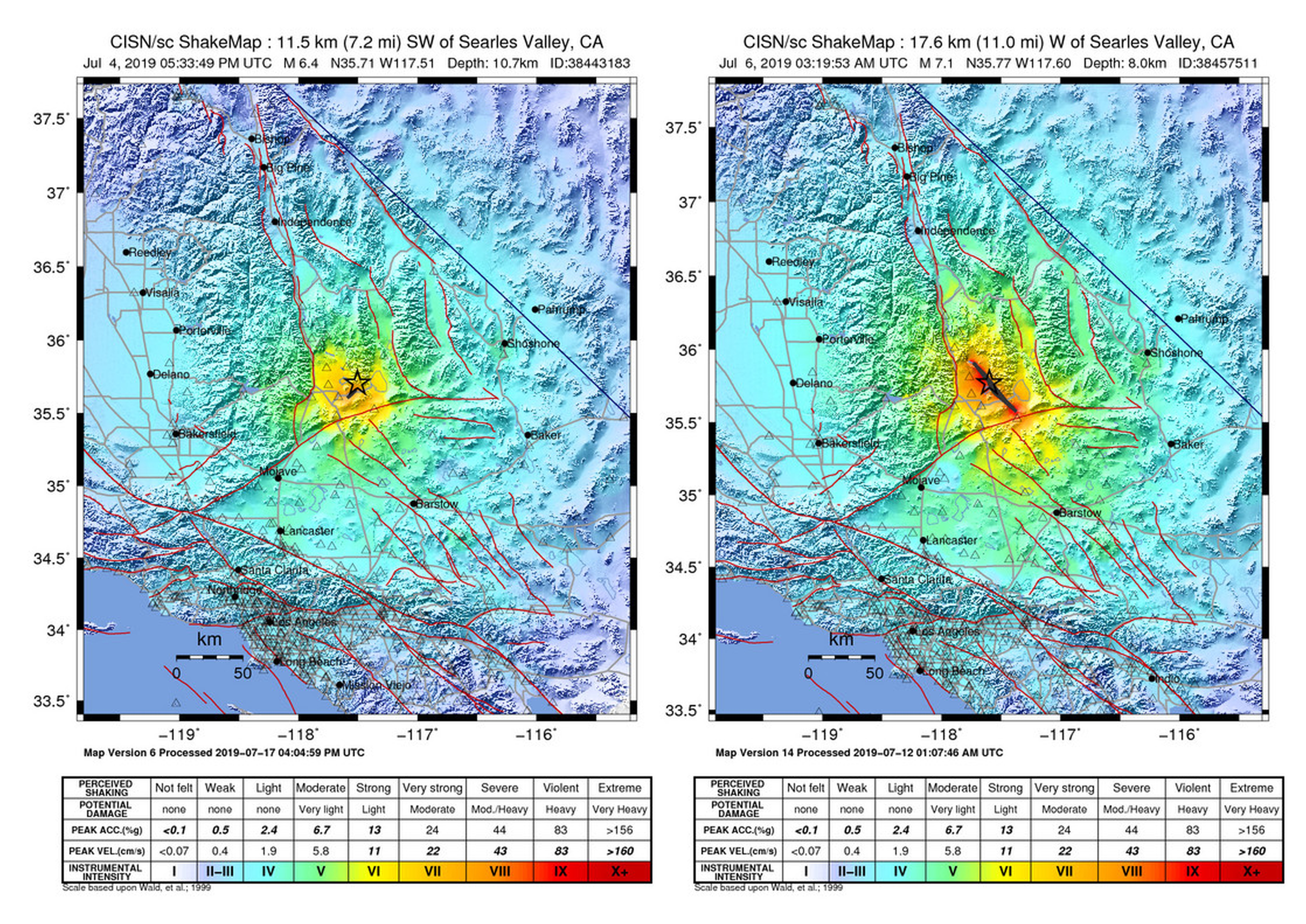
Comparison of “ShakeMaps,” or maps of shaking, for the M6.4 (left) and M7.1 (right). Produced by the U.S. Geological Survey. / Image: SCEC screenshot compilation.


Modified Mercalli Intensity scale used for shading in ShakeMaps, and descriptions of each level of shaking. Image: SCEC screenshot of USGS Earthquake Hazards Site.
Our experience of earthquakes can be highly subjective. As aftershocks are still continuing, they instill worry and uneasiness for some and complacency and indifference for others. While at a much lower rate now, they may continue for several weeks, months - even years. There are no deaths or serious injuries to report from these events and no widespread significant structural damage to commercial buildings. However, there is speculation that a man working on his vehicle during the earthquake may have died, to be confirmed. The issues that did occur were that under a dozen mobile homes faced collapse and a few houses caught on fire. This is a reminder to know how to turn off the gas if you smell it. Consider having an automatic gas shut-off valve and that it’s functioning properly; these devices are instrumental in preventing fires following earthquakes. Many chimneys collapsed; this is quite common as many chimneys are made of brittle bricks that easily crumble in earthquake shaking (and the good news is they can be reinforced). Some non-structural observations include the many products that fell off shelves in stores, and people’s furniture and appliances falling over. On July 9th, Governor Newsom’s request for federal aid was approved by President Trump which will help enhance recovery.

Searles Valley Earthquake Sequence including aftershocks as of July 9th, 2019 at 3:00 PM PT. Red lines indicate previously mapped faults. / Image: SCEC screenshot of USGS Recent Earthquakes Map.
Mostly built-up after the 1940s, the directly hit community of Ridgecrest may have come out better than others due to its relatively recent construction and sparse and rural population. Many single-family homes were built in the 1980s so they were built with more recent codes. Single family wood frame houses also tend to fare better than other types of structures, such as soft-story apartment buildings, according to SCEC’s Executive Director for Applied Science, Dr. Christine Goulet, who was among the many researchers collecting data in the Ridgecrest area right after the M6.4 foreshock.
“Being out in the field during the M7.1 was a life-changing experience for me and my colleagues in earthquake research and engineering,” says Goulet “As part of the Geotechnical Extreme Event Reconnaissance (GEER) team, I gathered information about how the earth moved in terms of fault displacement, liquefaction and lateral spreading. The GEER team also observed and documented structural damage and witnessed the toll these events took on the Ridgecrest and Trona residents, discussing with several of them and providing a technical context that seemed to reassure them."

Fault trace from the M6.4 earthquake. Note the footprints from earthquake tourists. This highlights the importance of fast data collection and reconnaissance activities; when a lot of people walk in the fault area, you lose the chance to make detailed measurements and get scientifically critical information. / Photo by: Christine Goulet, SCEC.
California is criss-crossed by hundreds of significant faults. We have expressions all around us of their vigorous activity that has shaped and carved our gorgeous scenery around the state, such as impressive mountains, green and seemingly endless hills, dramatic basins, wide and vast deserts, and serene, deep lakes. Some of our roadways and lifelines such as aqueducts, electricity transmission lines, and gas pipes intersect one or more significant faults, making them vulnerable to damage. The San Andreas fault, for example, runs through the state and delineates the contact of the huge North American and Pacific plates and intersects several lifelines in multiple spots.
While it will take some time to determine exactly which fault ruptured near Ridgecrest, the event is not a surprise in this region, called the Eastern California Shear Zone, which contains a collection of many faults from near Joshua Tree in the south up through the Owens Valley to the north. These other faults are powerful in their own right, and have produced the largest earthquakes in the last 40 years in southern California, including the 1992 M7.3 Landers and 1999 M7.1 Hector Mine earthquakes. Of-course there have also been memorable earthquakes elsewhere in the state including the 1994 M6.7 Northridge Earthquake, the 1989 M6.9 Loma Prieta Earthquake, the 1971 M6.5 San Fernando Earthquake, and more recently, the 2014 M6.0 Napa Earthquake.
The M6.4 earthquake on Thursday morning broke in an “L”-shaped pattern, across two conjugate faults. Friday night and onward, the dramatically larger M7.1 earthquake and aftershocks caused the “L” to turn more into a “T” with its sequential, general pattern, highlighting the presence of a long fault structure trending from the NW to the SE.

Left: M6.4 and aftershocks July 4th through early evening July 5th.
Right: M7.1 earthquake and aftershocks, plus preceding activity. / Image by SCEC screenshot of USGS Recent Earthquakes Map Data.
 |
| Location of three M6.0+ earthquakes that have occurred since 1850 near Ridgecrest. Image by: SCEC screenshot of USGS earthquake catalog results displayed on map. |
Since 1850, there have been about 3 earthquakes in this immediate region of magnitude 6.0 or more; in all of California there have been 125 earthquakes of magnitude 6.0 or more. Nearby faults include the N-S trending Sierra Nevada, Wilson Canyon, Airport Lake, Ash Hill, Panamint Valley, and Tank Canyon fault, with Garlock fault to the south running E-W. The California Geological Survey’s Fault Activity Map is one such interactive tool that you can use to zoom in and around California to see faults near you.
All partners are working together to conduct field reconnaissance and perform manned and drone fly-overs, to capture data using a variety of earthquake imaging tools and techniques such as LiDAR, InSAR, structure from motion, and more. SCEC is coordinating with partners from the USGS, EERI, NASA, and several other SCEC core institutions to increase instrumentation in the area, including seismometers and GPS stations to capture data in the short and long term to track tremors and deformations. This will empower scientists to see how this earthquake sequence has affected the geological environment and to support better modeling.
Moving forward, remember that you can prepare to survive and recover from all the earthquakes in our future with the Earthquake Country Alliance’s (ECA) Seven Steps to Earthquake Safety: EarthquakeCountry.org/sevensteps. The ECA is a public-private-grassroots effort administered by SCEC in California to support earthquake and tsunami preparedness and mitigation. You can also participate inGreat ShakeOut Earthquake Drills and commit to practicing Drop, Cover, and Hold On for one minute each year, on the third Thursday of October, coordinated worldwide by SCEC.

Screenshot of CGS fault map zoomed in on Ridgecrest, CA
Key Resources:
- M7.1 Earthquake near Ridgecrest, CA / USGS
- M6.4 Earthquake near Ridgecrest, CA / USGS
- Recent earthquakes, worldwide / USGS
- Great ShakeOut Earthquake Drills / ShakeOut
- Seven Steps to Earthquake Safety / ECA
- Earthquake Engineering Research Institute / EERI
- National Science Foundation / NSF
- U.S. Geological Survey / USGS
Reporters seeking interviews and other needs should email Mark and Jason directly, SCEC's media contacts, and consult SCEC.org/media.
We study why and how earthquakes occur, evaluate their effects,
and help societies prepare to survive and recover.
Headquartered at the University of Southern California with a
community of more than 1,000 scientists across 75 institutions.


