| 2011 Research Projects |
|
GPS Monitoring of San Andreas Fault 2011 and San Jacinto Fault Trenching
|
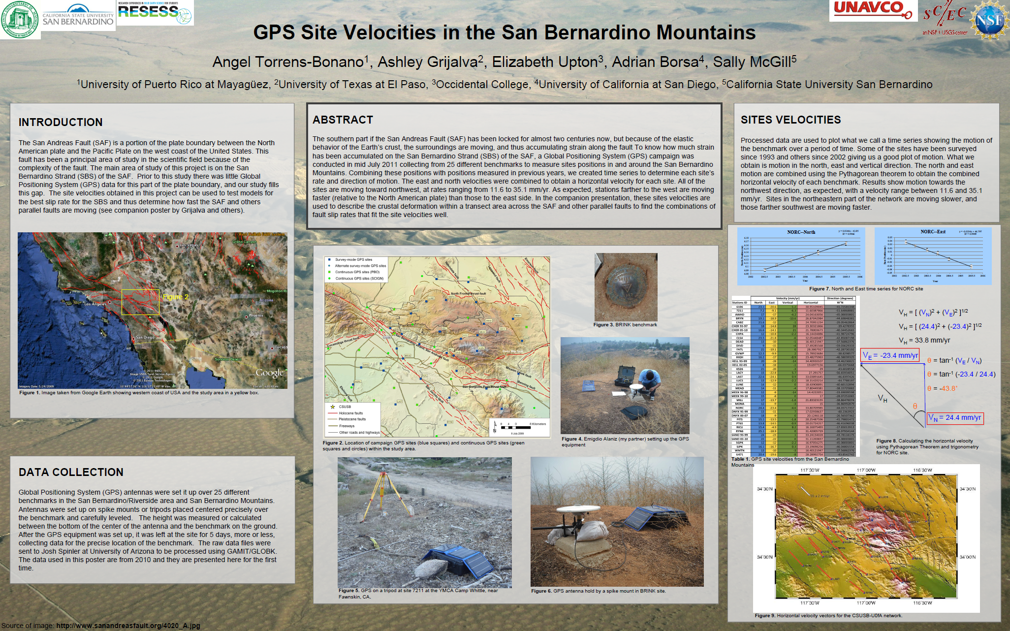
Project Description: (Note: This description was revised on 1/21/11. The trenching project has been rescheduled from May to August). Interns selected for this project will participate in two different projects: (1) (during July) collection and interpretation of GPS data to monitor strain accumulation across the San Andreas and San Jacinto faults, and (2) (during August) studying prehistoric earthquakes on the northern San Jacinto fault recorded in sedimentary layers exposed in a trench across the fault near Hemet. Both projects require extensive field work, much of which will occur in hot weather. Expect long days while we are doing field work. For the GPS data collection, interns will travel in pairs throughout the San Bernardino Mountains and surrounding valleys to set up GPS equipment and monitor it throughout the day. Many of the sites are remote and will require strenuous hiking, carrying the GPS equipment as well as batteries and/or a solar panel. Most sites will require car camping. The interns should be in good physical condition and should enjoy hiking. Interns will have access to CSUSB’s 4WD vehicle for travel to field sites(if they have a valid CALIFORNIA driver’s license), or may be reimbursed for mileage on their own vehicles. Interns will help to prepare the GPS equipment in early July. A 3-day GPS training program will be held July 11-13 for the interns and other students and high school teachers who will participate in the data collection. Data collection will be from July 14-20, with the remainder of July spent interpreting the data and creating a poster of GPS results. During this time, interns will learn how to interpret GPS time series from previously collected data and to conduct one-dimensional elastic modeling of GPS data for fault slip rates in southern California. The San Jacinto fault trenching will take place in early August. Field work will include scraping trench walls, setting up string grids, etching contacts and faults in the trench wall with a probe or nail and photographing each panel of the grid. Conditions in the trench will be muddy. Office work will continue into mid-August and will include rectifying the photographs in Adobe Photoshop, combining them into a mosaic that covers the whole trench, drawing final interpretations on the photomosaics and creating a poster presenting the interpretation of prehistoric earthquakes exposed in the trench. All interns will participate in the field work for both projects (if their school schedule permits) and will have a choice of which project to focus on for their poster presentation at the SCEC meeting. For interns who do not live within easy commuting distance of San Bernardino I will post an email announcement on our campus email soliciting faculty and staff who have a room to rent. Interns will pay for rent and other living expenses out of their stipend.
Intern(s): Robert Mason, Elizabeth Upton, Emigdio Alaniz, Kaliymah Muhammad, Angel Torrens-Bonano, Ashley Grijalva
Mentor(s):
Sally McGill, California State University, San Bernardino
Valerie Sloan, UNAVCO
|

Click here for Uptown's Project
Click here for Mason's Project
Click here for Alaniz's Project
Click here for Muhammad's Project
Click here for Torrens-Bonano's Project |
|
Developing a Three-Dimensional Geological and Geophysical Model of the Crust Along the East Side of the Southern San Andreas Fault
|
Project Description: Improving models of crustal structure is necessary to accurate calculation of earthquake hypocenters, and to understanding how crustal architecture influenced the development of faults in southern California. The summer intern will use a tilted crustal cross section exposed in the eastern Transverse Ranges to build a model of crustal structure along the east side of the southern San Andreas fault. The project will begin with field work along sampling transects through a tilted crustal section in the Little San Bernardino Mountains, describing and sampling key rock units. Following fieldwork, the intern will be responsible for carrying out laboratory measurements of rock density, magnetic susceptibility and anisotropy, and radiogenic heat production, and use computer modeling to construct images of crustal seismic velocity variations. The summer intern should have a background in petrology and/or geochemistry, and enjoy both laboratory work and field work in mountainous terrain. Experience in GIS would be a plus. This project will contribute to the SCEC Unified Structural Representation project in the development of a 3D model of Earth structure in southern California.
Intern(s): Carl Symcox
Mentor(s):
Andrew Barth, Indiana University
Scott Paterson, University of Southern California
|
Click here for Symcox's Project |
|
|
Understanding Seismic Anisotropy in the Lower Crust of Southern California Using Mineralogy and Mineral Physics
|
Project Description: Seismic anisotropy occurs when seismic waves travel faster in one direction than in another, and can have a number of causes. Understanding the causes and distribution of seismic anisotropy in the lower crust of southern California will help in the interpretation of seismic data from this region, including developing a better crustal model. The main goal of this research project is to predict the magnitude and orientation of seismic anisotropy by measuring samples of the lower crust that are now at the surface. To do this we use electron backscatter diffraction (EBSD) to measure crystallographic preferred orientations (CPOs) of minerals in samples of the Pelona Schist, which underplates much of southern California. We combine the measured CPOs with the mineral elastic constants to calculate the seismic velocities in all directions of the rock. We are looking for one intern to help collect and analyze this data. The intern will assist in collecting new samples on a 2-3 day field trip. This will involve camping and a moderate amount of hiking. The intern will also learn how to operate a scanning electron microscope (SEM) and make EBSD measurements, as well as how to calculate seismic anisotropy from EBSD data. Together, we will interpret the results of the measurements and calculations in terms of what they mean for the seismic anisotropy of the lower crust of southern California.
Intern(s): Kelsey Wagner
Mentor(s):
Sarah Brownlee, University of California, Santa Barbara
Bradley Hacker, University of California, Santa Barbara
|
 |
|
Collaborative Research: Rupture Propagation and Slip at Complex Fault Intersections: The San Andreas-San Jacinto-Cucamonga Fault Intersection in Cajon Pass
|
Project Description: The intersection of the San Andreas, San Jacinto, and Cucamonga faults in Southern California is quite geometrically complex, and the true fault geometry is not well constrained; it is not clear which faults cut other faults, and where the various faults terminate. This issue is of great scientific and practical importance: The geometry of the fault intersection can lead to complex stress interactions between the fault segments, and thus can have a controlling influence on whether an earthquake terminates at the intersection, or can propagate through, leading to a larger earthquake. Our project is to numerically model earthquakes in the vicinity of this fault intersection under a variety of different assumptions about the fault intersection geometry. In this way, we will be able to evaluate the likelihood of fault-to-fault rupture propagation, and work toward more realistic estimates of seismic hazard in the region. The numerical models will utilize the dynamic 3D finite element method, which requires the construction of a finite element mesh that accurately represents the complex fault geometry. Currently, there exists no interface between our finite element software and the mesh generator software. The main task of the intern will be to construct such an interface so that the realistic fault geometry may be generated in the meshing software, and then input into the finite element code. After completing the interface, the intern will help set up and run the dynamic faulting models, and analyze the results.
Intern(s): Bryan Gulotta
Mentor(s):
David Oglesby, University of California, Riverside
James Dolan, University of Southern California
|
Click here for Gulotta's Project |
|
Preparing Trial Models of Spatial Variability in Geotechnical Velocities for Assessing Effects on Ground Motions
|
Project Description: This project is examining the effects of spatial heterogeneity of site conditions on predicted ground motions by completing several tests:
- An examination of the spatial statistics of Vs100 (average shear velocity to 100 m depth), Z0.5 (depth at which shear velocity rises to 0.5 km/s), and other metrics that can be derived from the data set of prior Vs(Z) measurements.
- Development of a method to augment the SCEC CVM with a stochastic geotechnical layer, holding to the spatial statistics of local measurements, and transfer of this method to the group maintaining the CVM. SCEC Interns will help here by preparing trial geotechnical maps with alternative statistical inputs.
- Set-up and running of Olsen’s (2000) LA Basin scenarios with stochastic geotechnical layers, including verification of consistency with Olsen’s results, and sensitivity tests of highly variable geotechnical layers against smooth geotechnical properties.
- Examination of the spatial statistics of the ground motions output from the stochastic-geotechnical scenarios. SCEC Interns will help the graduate students examine the trial results.
- Presentation of results at SCEC workshops and the SCEC Annual Meeting (with Intern presentations), and journal publication.
Intern(s): William Savran
Mentor(s):
John Louie, University of Nevada, Reno
Roxanna Frary, Graduate student
Annie Kell-Hills, Graduate student
|
 |
|
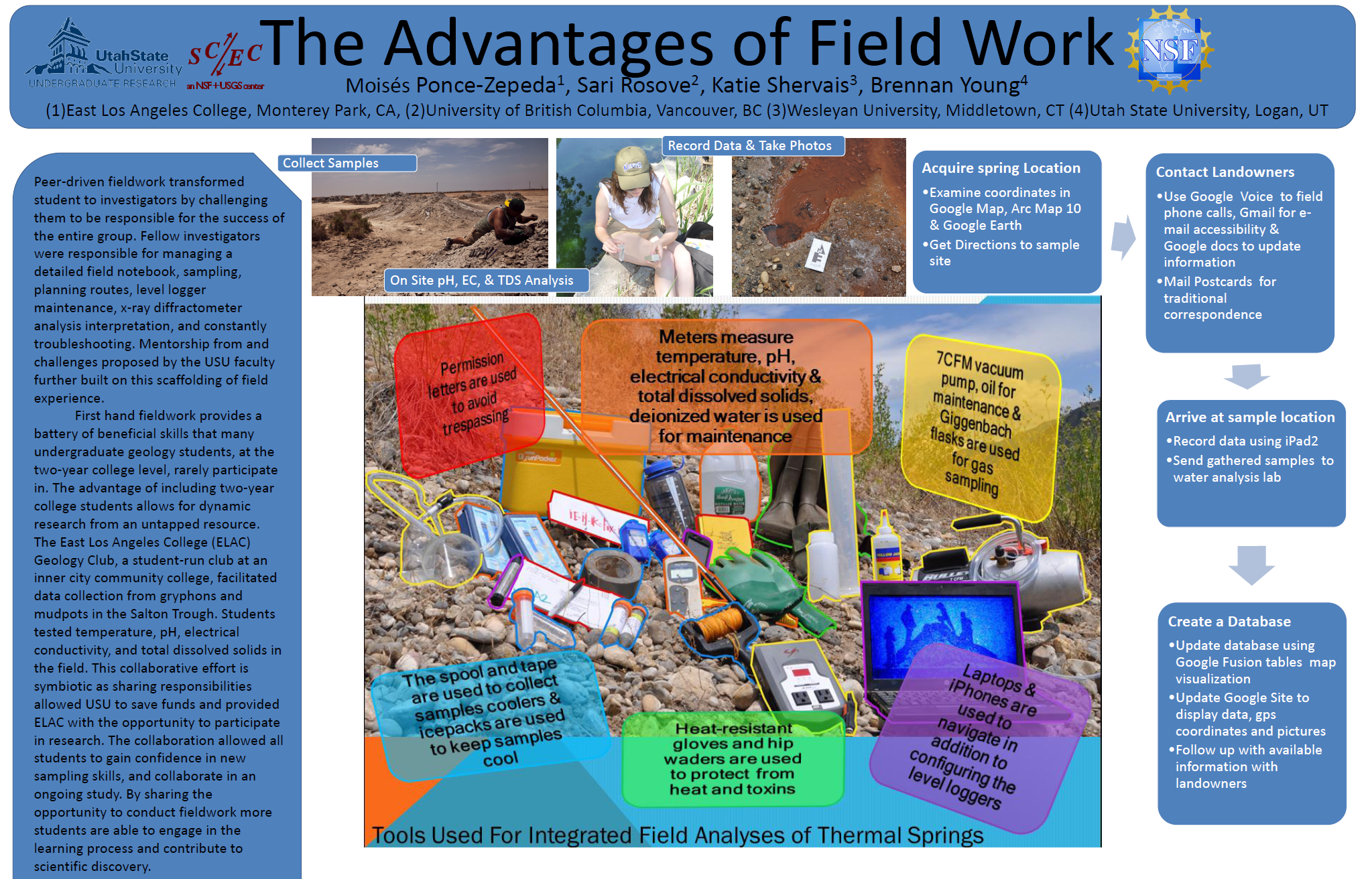
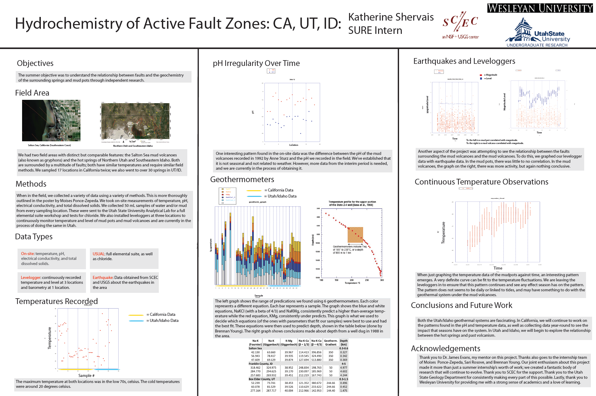
Hydrochemistry and Hydrothermal Alteration Along Active Faults
|
Project Description: The Aqua Caliente hot springs, and several other small springs, lie along the trace of the Elsinore fault. In conjunction with a graduate student working on the hydrothermal alteration and deformation in the rocks adjancent to the fault, the undergraduate intern will collect time series data on water conditions, as well as systematically sample and analize the water chemistry from the springs. The objectives of the project are to determine the baseline water chemistry of the springs, and to determine if there are any changes associated with small swarms of earthquakes that occur 3-5 km away.
Intern(s): Sari Rosove, Katherine Shervais, Moises Ponce-Zepeda
Mentor(s):
James Evans, Utah State University
Jerry Fairley, University of Idaho
Rebekah Wood, Utah State University
Nate Onderdonk, California State University, Long Beach
|
Click here for Rosove's Project |
|
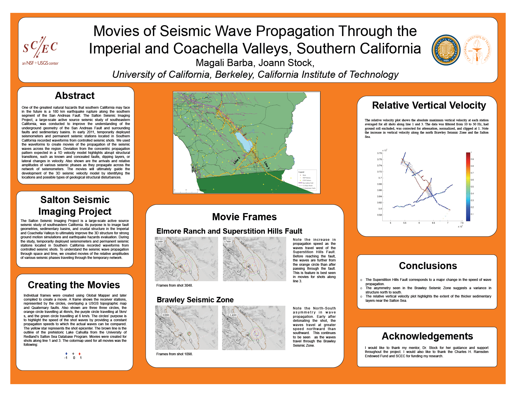
Salton Seismic Imaging Project: Evaluating the Seismic Velocity Structure of Southeastern California
|
Project Description: The Salton Seismic Imaging Project, or SSIP, is a large-scale active source seismic study of southeastern California, taking place in Feb and March 2011. Its controlled seismic shots will be recorded by an array of temporarily deployed seismometers between San Diego and the Colorado River, and from Palm Springs to the Mexican border. The shots will also be detected at permanent seismic stations in southern California. We seek one or two SCEC interns to use a subset of the shots and arrivals at Southern California Seismic Network stations, to evaluate how the shots were recorded across the permanent network, pick arrivals from the waveforms, and use these to test and refine the 3D seismic velocity model for part of the region. The exact area to be studied will be chosen after the SSIP active source experiment is finished but may include, for example, part of the eastern Peninsular ranges or the western side of the Salton trough.
Intern(s): Ernesto Jimenez, Magali Barba, David Rodriguez-Castro
Mentor(s):
Joann Stock, California Institute of Technology
Egill Hauksson, California Institute of Technology
|


Click here for Jimenez's Project
Click here for Rodriguez's Project |
|
Automated Earthquake Seismology
|
Project Description: This internship would use recordings of seismic waves (seismograms) to develop a new kind of earthquake catalog for the central San Andreas Fault. Many earthquakes on this part of the fault occur as repeating ruptures of the same fault area and produce nearly identical waveforms. The intern would work with Greg Beroza (Stanford), and Bill Ellsworth, Justin Rubinstein and David Shelly (USGS Menlo Park) to build a catalog based on the similarity of waveforms instead of the traditional detection/location approach. The resulting catalog will be used to explore two research questions (two interns would be welcome on this project). One project will focus on quantifying and understanding the aftershock behavior of repeating earthquakes. A second project will explore the properties of sequences of repeating earthquakes, and work towards understanding the behavior of these events. Good computer skills are a big plus for this internship. There is also the opportunity for interns to present their work at the Southern California Earthquake Center meeting in Palm Springs in September.
Intern(s): Raymond Chen
Mentor(s):
Greg Beroza, Stanford University
William Ellsworth, Stanford University
David Shelly, United States Geological Survey
Justin Rubinstein, United States Geological Survey
|

Click here for Chen's Project |
|
Investigating the Impact of Space-Geodetic Data on Earthquake Risk Analysis for Southern California
|
Project Description: Traditionally, Probabilistic Seismic Hazard Assessment (PSHA) studies have been based on earthquake and paleoseismic observations. Recent research focuses on the inclusion of space-geodetic date (like GPS and INSAR) in PSHA work, mainly to contribute to estimates of slip rates on active faults, but also to complement present-day crustal deformation rates that are purely based on earthquake data. Southern California is monitored by a dense network of GPS stations, producing a high resolution velocity field of the Earth’s surface. One way of translating this velocity field into crustal deformation parameters that can be used in PSHA is the ‘block model’. In the block model the crust is parameterized as a number of elastically deforming blocks, bounded by surfaces that represent the major active faults. A number of these block models has been published for Southern California. Based on differences in underlying methods and assumptions they produce significant differences in terms of fault slip rates, geometry of the building blocks and location of the faults. The work proposed here will be executed at the Newark, California, based office of Risk Management Solutions, Inc. (RMS), a company that develops catastrophe risk models for the insurance industry. The project focuses on the impact of the inclusion of space-geodetic observations, GPS and perhaps INSAR data, on earthquake risk in Southern California. Earthquake risk combines earthquake hazard and building vulnerability to estimate the probable damage or loss. The first part of the project encompasses the translation of the main existing block models into PSHA hazard/risk models. In the second part of the project we look at the impact of space-geodetic data on risk by comparing traditional risk models with space-geodetic risk models. Finally, we compare risk results from the various block models to develop an idea of the sensitivity of damage and loss to the different underlying block models assumptions.
Intern(s): Chi Ming Mak
Mentor(s):
Marleen Nyst, Risk Management Solutions, Inc.
Wayne Thatcher, United States Geological Survey
|

Click here for Mak's Project |
|
Investigations into Geodetic/Seismic Early Warning Systems for Natural Hazards
|
Project Description: The SOPAC research group would like to mentor an undergraduate student under the SURE Project. We have several projects whose goal is to integrate data from seismic and geodetic (GPS) networks for the purposes of early warning and rapid modeling of natural hazards events (earthquakes, volcanoes, tsunamis, flooding, landsliding). The intern will work with the PI and 2 SIO graduate students in the collection, analysis, and modeling of real-time GPS and seismic data in the Western U.S. and Mexico, focusing on earthquake early warning systems and rapid earthquake response. The intern will also interact with other SCEC institutions working on this topic.
Intern(s): Hillary Tahtinen
Mentor(s):
Yehuda Bock, University of California, San Diego
Brendan Crowell, University of Washington
Diego Melgar, Graduate student
|

Click here for Tahtinen's Project |
|
Make Your Own Earthquake: Curriculum Development for Grades 6 - 12
|
Project Description: The San Andreas fault in the Carrizo Plain has been a target of our paleoseismology research for more than 20 years. This year, we plan to excavate the fault at Wallace Creek in the Carrizo National Monument, and nearby sites, to expose Holocene ruptures and collect samples for radiocarbon dating. The results will be used to better constrain the slip rate and slip history of this important fault. We seek an intern to help with field work and office work. The office work involves drafting trench logs and organizing samples, logs, and other data.
Intern(s): Joseph Trudeau, Sean Allen, Heidi Pence
Mentor(s):
Jamison Steidl, University of California, Santa Barbara
Sandy Seale, University of California, Santa Barbara
Francesco Civilini, University of California, Santa Barbara
Hank Ratzesberger, Interpublic Group
Paul Hegarty, University of California, Santa Barbara
|

Click here for Trudeau's Project
Click here for Allen's Project |
|
Dynamic Rupture Models of the 1992 Landers Earthquake
|
Project Description: The intern will run computer simulations of the 1992 Landers earthquake. The objective is to investigate how complex fault geometry leads to irregular rupture propagation and the excitation of incoherent high frequency ground motion. The intern will first use maps of the fault system to build a realistic model of the fault geometry. The next step is to determine the set of initial conditions (in terms of stresses and friction law parameters) that permits rupture across the entire fault system at reasonable speeds. Additional constraints will come from measured slip distributions and from the strong motion records. The final step will be to analyze the rupture history and attempt to relate specific phases on the seismograms to geometric features of the fault system.
Intern(s): Audra Delauder
Mentor(s):
Eric Dunham, Stanford University
|
Click here for Delauder's Project |
|
Promoting Community-Wide Drills to Improve Disaster Resilience in the Education Sector
|
Project Description: Intern will assist in current disaster preparedness public education focused on the experience of the education sector in community-wide disaster drills. Social media planning, evaluation, and training activities. Student will be part of a small team dispersed across the U.S. and will focus on development of information, education and communication products (Other team members will have skills in disaster management and data analysis). Tasks may include:
- Assist in development, analysis and interpretation of results of surveys of schools, school districts, colleges and universities (and possibly individual & families and businesses & organizations as well). Data comes from surveys of the 2008 Great Southern California ShakeOut, and the 2009 and 2009 Great California Shakeouts.
- Develop engaging reports, presentations, and web-resources to communicate trends in disaster preparedness, guidance for and benefits of education sector participation in community-wide drills.
- Compile and review existing guidance materials for university campus disaster drills in order to develop a guidance package from both existing and new materials.
- Support international outreach efforts such as: strategic planning to promote Disaster Resilient Universities, working with the Coalition for Global School Safety, Universidad Central de Venezuela or Boğaziçi University, Istanbul to support future activities.
Intern(s): Jillian Gorelick, Lindsay Davis, Alicia Leslie, Lindsay Orr, Andrea Jones, Dongsoo Han
Mentor(s):
Mark Benthien, University of Southern California
Michele Wood, California State University, Fullerton
Rebekah Green, Graduate student
Stephen Bender, Graduate student
|

Click here for Davis's Project
Click here for Leslie's Project |
|
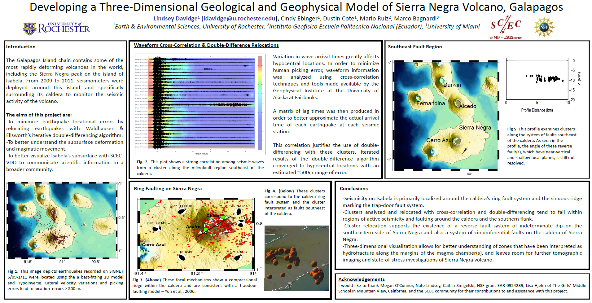
Developing a Three-Dimensional Geological and Geophysical Model of Sierra Negra Volcano, Galàpagos
|
Project Description: Three-dimensional visualizations of ocean island volcano systems aid in the integration of spatially and temporally diverse data sets, and enable non-experts to gain a background understanding of geohazards. Basaltic shield volcanoes in the western Galapagos Island chain are the most rapidly deforming volcanoes worldwide, and they are visited by thousands of tourists each year. The summer intern will use existing earthquake epicentral locations, topography/bathymetry, and InSAR inteferograms to compare time-varying patterns in surface and brittle deformation fields as imaged in 3D. The resulting visualizations will be used in the Galapagos National Park information center, and updated as new information becomes available. The project will involve earthquake relocations using cross-correlation and cluster analyses, as will as an introduction to satellite geodesy.
Intern(s): Lindsey Davidge
Mentor(s):
Cynthia Ebinger, University of Rochester
Dustin Cote, University of Rochester
Falk Amelung, University of Miami
Marco Bagnardi, University of Leeds, Leeds
|
 |
|
Mapping the 1892 Mw 7.1 Laguna Salada Earthquake
|
Project Description: This project will focus on mapping the Laguna Salada fault zone in northern Baja California. The work is aimed at quantifying strain produced in the 1892 Mw 7.1 Laguna Salada earthquake, its relationship to broader fault zone structure and the reactivation of fault slip during the 2010 Mw 7.2 El Mayor-Cucapah earthquake. In short, the project seeks to define moment release in 1892 and the broader structural geology as defined by existing field mapping and seismicity illuminated by the 2010 event. The work will build on efforts by SCEC scientists to understand the interaction of the earthquakes in 1892 and 2010 and their implications for seismic hazard posted by future strike slip earthquakes in Southern California. The work will include mapping of the entire Laguna Salada fault zone including Late Quaternary fault scarps, older inactive faults in the zone and alluvial deposits offset by structures in the region. Mapping will utilize high resolution LiDAR data shot along the fault zone, which has already been uploaded to the Active Tectonics Lab at Boulder. The LiDAR data will form the basis for mapping key features. Data will be compiled and analyzed using Google Earth Pro, using methods currently being developed by John Fletcher’s group at CICESE in Ensenada. Products will include:
- A 1:5000 map of faults in the zone, including active and inactive structures
- Alluvial deposits that either are offset by faults and/or bury them
- Offsets along the faults, including measurements derived from the LiDAR and fieldwork already completed by SCEC scientists.
- Structural models in both map and cross section views that relate the proportion of vertical and lateral displacements to fault geometry, particularly along releasing bends where the proportion of lateral vs normal slip varies.
This project will involve collaboration with other SCEC researchers that have teamed up to describe the 1892 rupture (Rockwell, Teran, and others) as the project develops.
Intern(s): Patrick Patton
Mentor(s):
Karl Mueller, University of Colorado, Boulder
|

Click here for Patton's Project |
|
Earthquake EPIcenter Product Development Project
|
Project Description:
Intern(s): Mary Mclellan
Mentor(s):
Robert de Groot, University of Southern California
|
Click here for Mclellan's Project |
|
Creative World Earthquake Preparedness Programming
|
Project Description: Seven Steps Program for Free-Choice Learning Institutions
Intern(s): Michelle Vanegas, Monica Barajas
Mentor(s):
Robert de Groot, University of Southern California
|
Click here for Vanegas's Project |
|
Promoting Community-Wide Drills to Improve Disaster Resilience in the Education Sector
|
Project Description:
Intern(s): Andrea Nguyen
Mentor(s):
Marla Petal, Risk Reduction Education for Disasters (Risk RED)
|
|
|
San Andreas Fault Active Earth Kiosk
|
Project Description:
Intern(s): Dung Hoang
Mentor(s):
Robert de Groot, University of Southern California
|
|


