Poster #226, Ground Motions
Database of geotechnical shear-wave seismic-velocity profile measurements for California and Nevada

Poster Image:

Poster Presentation
2020 SCEC Annual Meeting, Poster #226, SCEC Contribution #10493 VIEW PDF
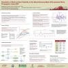
view/vs-profile-archive documents all of these measurements, with DOI 10.5281/zenodo.3951865, also accessible from https://Louie.pub. The site leads to a directory structure grouping the measurements by region, and the files are often named with a monitoring network station name. Earthquake-monitoring stations are often on bedrock; the database also includes the results of transects across the Reno, Las Vegas, and Los Angeles urban basins that are mostly deep soil sites. Each file is a self-explanatory, plain-text list of the data and results from the measurement. Measurements made at slightly different ReMi array locations, at different times, and by different interpreters produced multiple files for some sites. The multiple results express both the aleatory variation of velocity in the ground, and the epistemic variability of the measurement technique. Each measurement file includes ReMi array-location data, a summary Vs30 value, and a modeled shear-wave-velocity-versus-depth profile. Efforts are underway to add the picked ReMi p-f image and the picked fundamental-mode Rayleigh-wave dispersion-curve data to each file. These archives give additional details on ReMi measurements found in the US Geological Survey's Vs30 archive at https://earthquake.usgs.gov/data/vs30/us/ . An additional 10,722 Vs30 measurements in Las Vegas and Clark County, Nevada are available from the Clark County GIS system at http://gisgate.co.clark.nv.us/ow/ (select the "Seismic" map type).
SHOW MORE
SHOW MORE
Lightning Talk
Full Presentation
Citation: Louie, J. N., Simpson, A. R., & Ortega, J. (2020, 08). Database of geotechnical shear-wave seismic-velocity profile measurements for California and Nevada. Poster Presentation at 2020 SCEC Annual Meeting.
Keywords: Vs30, shear-wave velocity profile, seismic site classification
MORE FROM GROUND MOTIONS

|

|
|

|

|

|
|

|

|

|

|

|

|
|

|

|

|

|

|

|
|

|

|