Poster #134, Fault and Rupture Mechanics (FARM)
Developing a Database for the Fragile Geologic Features at the Trona Pinnacles National Monument


Poster Image:

Poster Presentation
2020 SCEC Annual Meeting, Poster #134, SCEC Contribution #10571 VIEW PDF
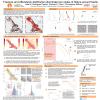
n estimation methodologies. Several days after the mainshock, a SCEC team from USC visited the Monument to photograph the spires. A team from JPL Caltech also imaged selected features using unmanned aerial vehicles (UAVs), while the USGS estimated tensile strength of several spires using a rebound hammer on distinct sedimentologic facies elements of each feature. The spires have also been heavily photographed by tourists prior to the RES, documenting their pre-event condition. We propose to develop a database to aggregate all these observations. The database will be made available to researchers working on ground motion estimation from FGFs.
The dataset will be similar in form to the existing SCEC precariously balanced rocks (PBR) database. We first develop a framework to collect and aggregate the information. This is primarily done with a combination of Matlab, kml and html scripts to collect EXIF information and populate Google Earth maps with oriented photographs for easy viewing. We then identify and assign numbered IDs to the spires by interpreting the photographs in conjunction with the Google Earth maps and the 3D images provided by the UAV images. We will then systematically search and catalog pre-event photographs of the FGFs. The final database will be created using our framework and exported as data tables and a set of web pages that include a numbered ID for each spire, its precise coordinates, links to photographs of the spires, strength measurements, and other additional data, if available.
SHOW MORE
Lightning Talk
Citation: Devine, S. C., Meng, X., Goulet, C. A., Donnellan, A., McPhillips, D., & Lyzenga, G. A. (2020, 08). Developing a Database for the Fragile Geologic Features at the Trona Pinnacles National Monument. Poster Presentation at 2020 SCEC Annual Meeting.
Keywords: Ridgecrest, Fragile Geologic Features, Database
MORE POSTERS BY THE AUTHORS

|

|

|

|

|

|

|

|


MORE FROM FAULT AND RUPTURE MECHANICS (FARM)

|

|

|

|

|
|

|

|

|

|

|

|

|

|

|

|
|
|

|

|

|

|

|

|

|

|

|


