Poster #015, Earthquake Geology
San Andreas Fault Transition Zone: Where Large, Small, Coseismic, and Aeismic Slip Occurs: Parkfield-Cholame


Poster Image:

Poster Presentation
2020 SCEC Annual Meeting, Poster #015, SCEC Contribution #10766 VIEW PDF
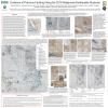
in, with a ~ 2 m incised stream channel. The 1966 surface rupture was mapped in detail (USGS Professional Paper 579), and the recently paved Highway 46 just south of the site shows creep-related cracking at the same location. Evidence for the 1966 surface rupture in the trench exposures is challenging to recognize. The topographic surface is slightly raised, (~0.1 m) along the fault with no clear evidence of the most recent rupture or creep-related cracking. However, a prominent buried moletrack, that is a well-defined upwarp ~ 30 cm high, ~ 5 m wide, exists at a depth of ~0.5 m. The upwarp is buried by layered onlapping overbank sediments. The underlying deposits show another upwarp of similar magnitude, as the sediments transistion into clay with soil development. We collected samples for C-14 and OSL chronology, with results pending. Our initial interpretation is that the prominent upwarps are the result of large displacement events like 1857. The event horizons occur at the tops of clay layers with the oldest showing soil development prior to incision. The uppermost large event occurs near the base of the overbank sediments, indicating that incision was minor.
Although we are challenged to recognize and quantify aseismic slip in fault excavations, this site provides another opportunity for missed creep, M6 dm-offsets, and M7+ surface rupture. This trench offers a unique opportunity to compare evidence between Parkfield and Cholame sites. The oldest event appears to be similar in width and uplift to older events documented at the Annette and LY4 locations (southeast along the Cholame segment) rather than at Parkfield or Dry Lake Valley (creeping section of the SAF). We do not find evidence for significant slip since 1857 at this location resulting in a slip potential in the 5 m range.
SHOW MORE
Citation: Seitz, G. G., Williams, A. M., Cook, D. K., Rockwell, T. K., & Arrowsmith, R. (2020, 08). San Andreas Fault Transition Zone: Where Large, Small, Coseismic, and Aeismic Slip Occurs: Parkfield-Cholame. Poster Presentation at 2020 SCEC Annual Meeting.
Keywords: San Andreas Fault, Paleoseismology, Parkfield
MORE POSTERS BY THE AUTHORS

|

|

|
|

|

|


MORE FROM EARTHQUAKE GEOLOGY

|

|

|

|
|
|

|

|

|
|
|

|

|
|
|


