Group B, Poster #102, Earthquake Geology
The Newport-Inglewood Fault at Long Beach: How Restraining Bends Control Slip Partitioning and Rupture Propagation Pathways Past and Future


Poster Image:

Poster Presentation
2022 SCEC Annual Meeting, Poster #102, SCEC Contribution #12446 VIEW PDF
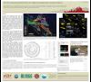
ata, including ~3600 horizon picks and fault penetrations from 220 oil wells, USGS QFaults surface traces, industry field maps and 2D seismic reflection surveys, we present a new 3D model of the NIF at Long Beach, and show it is much more complex than the simple, vertically-dipping system based on disconnected surface traces represented in regional models—rather, its strike-slip faults dip and curve, are connected by dip-slip faults, and intersect at depth.
The NIF at Long Beach consists of two main strands: the Cherry Hill fault (CHF) to the northwest, and the Reservoir Hill fault (RHF) to the southeast. A third strand, the Northeast Flank fault (NEFF), lies between these. Perpendicular to and linking the NEFF and CHF is the Pickler fault (PF). Our analysis of well data and modeling of the fold above the PF (which forms Signal Hill) indicates the PF dips 59° SE and accommodates pure dip-slip motion. Adjacent and connected to Signal Hill is Reservoir Hill, a second, smaller restraining bend formed where the Brine fault connects the NEFF and RHF. Well data indicate that the CHF and RHF dip toward each other and coalesce at depth, providing multiple direct fault linkages for slip to transfer from the RHF to CHF.
Regional strike-slip is translated into localized dip-slip across these restraining bends. They thus offer insight into the NIF’s slip history as expressed in vertical offset and uplift, and into how such systems may limit strike-slip ruptures, as is inferred for the 1933 earthquake.
We apply map-based restoration to model the displacement on each fault to show how slip has been partitioned among them over many earthquake cycles. We hope to compare these patterns with dynamic rupture models to assess how fault geometry may control rupture propagation over various timescales.
SHOW MORE
Citation: Toghramadjian, N., & Shaw, J. H. (2022, 09). The Newport-Inglewood Fault at Long Beach: How Restraining Bends Control Slip Partitioning and Rupture Propagation Pathways Past and Future. Poster Presentation at 2022 SCEC Annual Meeting.
Keywords: restraining bends, strike-slip faults, seismic hazard, 3D fault modeling, urban faults
Relevant SCEC Themes:
Special Fault Study Areas: Focus on Earthquake Gates
MORE POSTERS BY THE AUTHORS


MORE FROM EARTHQUAKE GEOLOGY

|

|

|

|

|

|

|

|

|

|

|

|


