Fault Scarp Degradation Analysis At Dragon’s Back Using High Resolution Topography Data
Emil Chang,
Gilles Peltzer, &
Seulgi Moon
Published September 8, 2016, SCEC Contribution #6535,
2016 SCEC Annual Meeting Poster #079
(PDF)
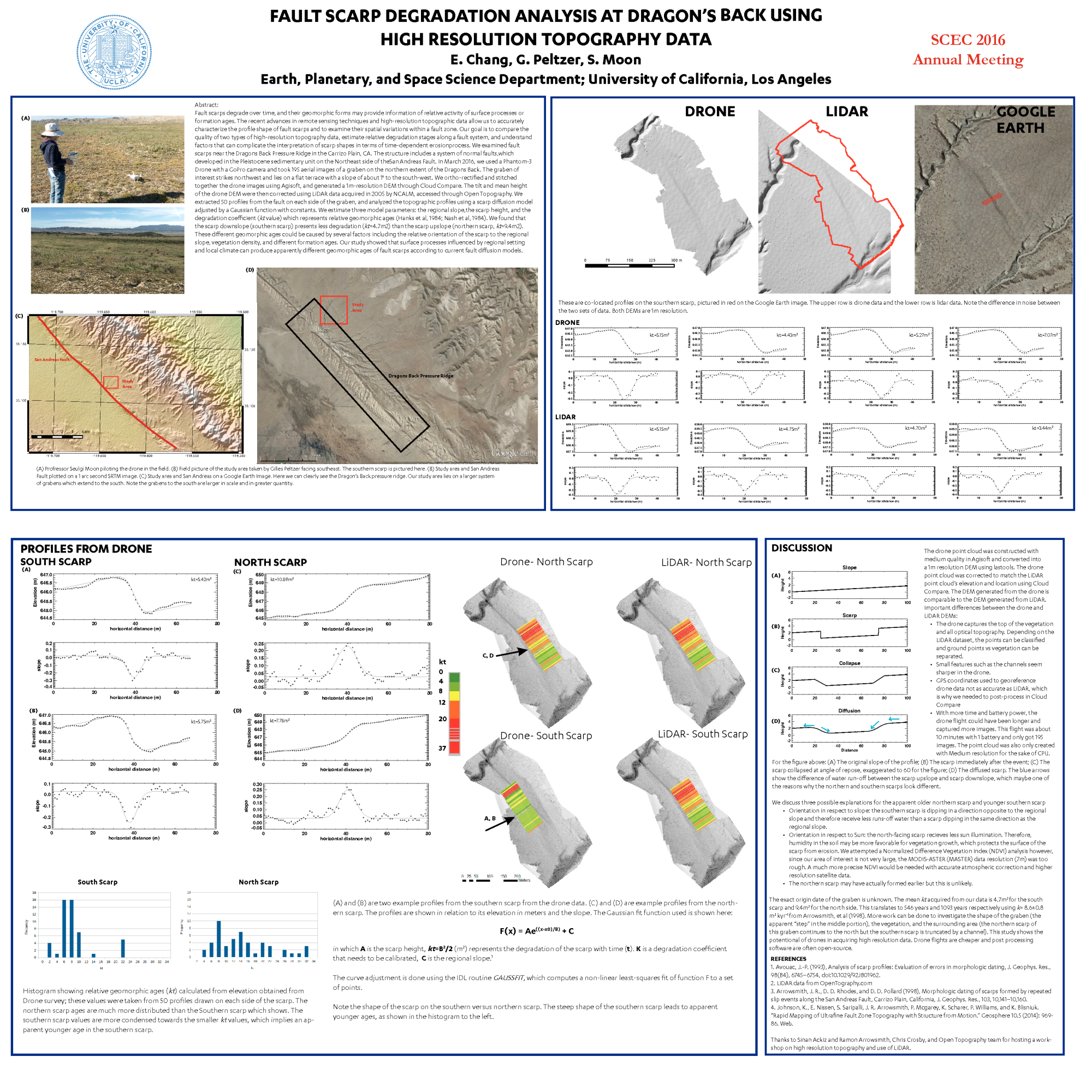
Fault scarps degrade over time, and their geomorphic forms may provide information of relative activity of surface processes or formation ages. The recent advances in remote sensing techniques and high-resolution topographic data allow us to quantify accurate geomorphic ages of fault scarps and to examine their spatial variations within a fault zone. Our goal was to quantify relative geomorphic ages, assess the quality of different types of high-resolution data, and understand factors that can complicate the interpretation of scarp dating techniques. We examined fault scarps near the Dragon’s Back Pressure Ridges in the Carrizo Plain, CA. The structure includes a system of normal faults, which developed in the Pleistocene sedimentary unit on the Northeast side of the San Andreas Fault. In March 2016, we used a Phantom-3 Drone with a GoPro camera and took 195 aerial images of a graben on the northern extent of the Dragon’s Back. The graben of interest strikes northwest and lies on a regional slope of about 1° to the southwest. We ortho-rectified and stitched together the drone images using Agisoft, and generated a 1m-resolution DEM through Cloud Compare. The tilt and mean height of the drone DEM were then corrected using LiDAR data acquired in 2005 by NCALM, accessed through Open Topography. We extracted 50 profiles from the fault on each side of the graben, and analyzed the topographic profiles using scarp diffusion models adjusted by a Gaussian function with constants. This function estimates three model parameters: the regional slope, the scarp height, and the degradation coefficient (kt value) which represents relative geomorphic ages (Hanks et al, 1984; Nash et al, 1984). We found that the scarp downslope (southern scarp) had a lower kt value, which a mean value of about 4.7m2, than the scarp upslope (northern scarp), which had a mean value of 9.4m2. These different geomorphic ages could be caused by several factors including the relative orientation of the scarp to the regional slope, vegetation density, and different formation ages. Our study showed that surface processes influenced by regional setting and local climate can produce apparently different geomorphic ages of fault scarps according to current fault diffusion models.
Key Words
lidar, high-resolution topography, fault, San Andreas
Citation
Chang, E., Peltzer, G., & Moon, S. (2016, 09). Fault Scarp Degradation Analysis At Dragon’s Back Using High Resolution Topography Data . Poster Presentation at 2016 SCEC Annual Meeting.
Related Projects & Working Groups
Earthquake Geology