Second Uniform California Earthquake Rupture Forecast (UCERF2)
| UCERF News |
| Documents and Resources |
A New Forecast of California Earthquakes
The 2007 Working Group on California Earthquake Probabilities (WGCEP 2007), a multi-disciplinary collaboration of scientists and engineers, has released the Uniform California Earthquake Rupture Forecast (UCERF)—the first comprehensive framework for comparing earthquake likelihoods throughout all of California. It provides important new information for improving seismic safety engineering, revising building codes, setting insurance rates, and helping communities prepare for inevitable future earthquakes.
In developing the UCERF, the 2007 Working Group revised earlier forecasts for Southern California and the San Francisco Bay Area (WGCEP 2003) by incorporating new data on active faults and an improved scientific understanding of how faults rupture to produce large earthquakes. It extended the forecast across the entire state using a uniform methodology, allowing for the first time meaningful comparisons of earthquake probabilities in urbanized areas such as Los Angeles and San Francisco Bay Area, as well as comparisons among the large faults in different parts of the state.
| This research was supported by: | |
The study was organized by the Southern California Earthquake Center, the U.S. Geological Survey, and the California Geological Survey, and it received major support from the California Earthquake Authority, which is responsible for setting earthquake insurance rates statewide.
During the three-year study, advice and comment was sought from the broader community of earthquake scientists and engineers through open meetings and workshops. Where experts disagreed on aspects of the forecast, alternative options were accounted for in calculations to reflect these uncertainties. The final forecast is a sophisticated integration of scientific data and expert opinion.
| Figures | |
|
|
|
| KML Files (for use with Google Earth) | |
| ucerf.kml | California map overlay of probability of at least one M >= 6.7 earthquake within 30 years |
| ucerf_smoothe.kml | California map overlay of probability of at least one M >= 6.7 earthquake within 30 years, smoothed |
| ucerf_smoothe_topo.kml | California map overlay of probability of at least one M >= 6.7 earthquake within 30 years, smoothed and with topography |
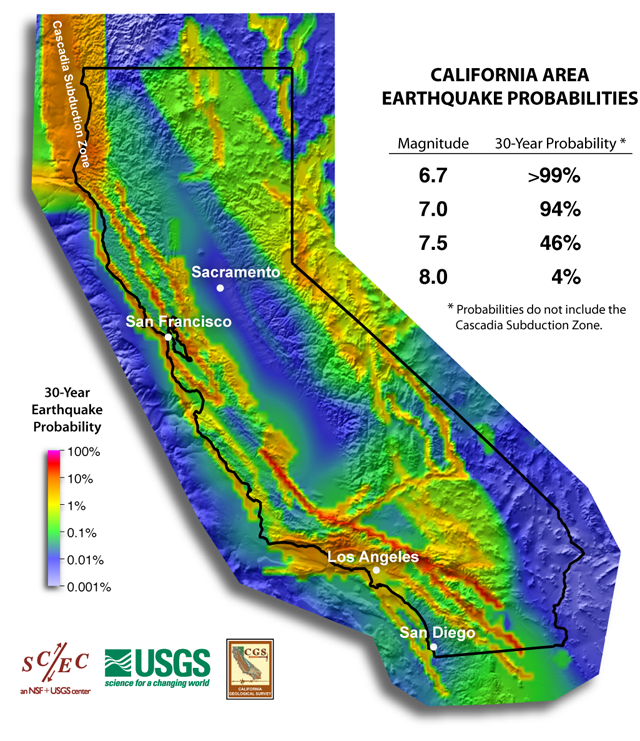


UCERF Earthquake Probabilities
The UCERF model includes the concept that earthquake likelihoods change with time. A fault that has ruptured in a recent large earthquake is less likely to produce another quake in the near future, because tectonic stress has not had time to build back up. Likewise, a fault that last ruptured a long time ago is more likely to produce an earthquake, because the stress on the fault has had time to re-accumulate. The faults with elevated probabilities for an earthquake include the southern San Andreas and Hayward-Rodgers Creek Faults (see Figure 5), although major quakes on these faults may still be decades away.
Earthquake Forecasting, Hazard, and Risk
Californians know that their state is subject to frequent—and sometimes very destructive—earthquakes. Accurate forecasts of the likelihood of earthquakes can help people prepare for these inevitable events. Because scientists cannot yet make precise predictions of the date, time, and place of future quakes, forecasts must be in the form of the probabilities of quakes of certain sizes occurring during specified periods of time.
In daily living, people are used to making decisions based on probabilities—from the flip of a coin (50% probability of heads) to weather forecasts (such as a 30% chance of rain) to the annual chance of being killed by lightning (about 0.0003%). In comparison, the probability of a magnitude 7.5 or greater earthquake striking somewhere in California is about 2% per year.
Earthquake probabilities derived by scientists can help people plan and prepare for future quakes. When an earthquake occurs, two things happen. The first is a fault rupture—a crack in the Earth’s crust—gives way and slips under tectonic stress. The second is the radiation of seismic waves caused by this sudden fault motion, which spread out like ripples from a pebble tossed into a pond. The ground shaking that occurs as these seismic waves pass by causes most of the damage. The strength of the waves at a particular site depends on the earthquake’s magnitude, which measures the size of the fault rupture, the distance of the site from the rupture, and the local geological conditions at the site.
The UCERF study has determined the probabilities that different parts of California will experience earthquake ruptures of various magnitudes (“earthquake rupture forecast”) but not the likelihood of shaking that will be caused by these quakes (“seismic hazard”). This is an important distinction, because even areas with a low probability of fault rupture can experience shaking and damage from distant, powerful quakes.
The U.S. Geological Survey is incorporating the UCERF into its official estimate of California's seismic hazard, which in turn will be used to update building codes. Other subsequent studies will add information on the vulnerability of manmade structures to estimate expected losses, which is called “seismic risk.” In these ways, UCERF will help to increase public safety and community resilience to earthquake hazards.
The results of the UCERF study serve as a reminder that all Californians live in earthquake country and should therefore be prepared (see Putting Down Roots in Earthquake Country). Although earthquakes cannot be prevented, the damage they do can be greatly reduced through prudent planning and preparedness. The ongoing work of the Southern California Earthquake Center, U.S. Geological Survey, California Geological Survey, and other scientists in evaluating earthquake probabilities is part of the National Earthquake Hazard Reduction Program’s efforts to safeguard lives and property from the future quakes that are certain to strike in California and elsewhere in the United States.
Additional Links:
Working Group on California Earthquake Probabilities
National & Regional Seismic Hazard Maps
National Earthquake Hazard Reduction Program
Southern California Earthquake Data Center
Putting Down Roots in Earthquake Country
ShakeOut annual earthquake drill
Media Contacts
| San Francisco Bay Area Leslie C. Gordon Geologist/Public Affairs Specialist U.S. Geological Survey (Menlo Park) (650) 329-4006 lgordon@usgs.gov |
Southern California Mark Benthien Director of Communication, Education & Outreach Southern California Earthquake Center (Los Angeles) (213) 740-5843 scecinfo@usc.edu |
Sacramento Don Drysdale Public Information Officer California Geological Survey (Sacramento) (916) 445-0633 ddrysdale@consrv.ca.gov |
| East Coast Clarice Nassif Ransom Public Affairs Specialist U.S. Geological Survey (Reston) (703) 648-4299 cransom@usgs.gov |
Pacific Northwest Stephanie Hanna Office of Communications Chief U.S. Geological Survey (Seattle) (206) 220-4573 shanna@usgs.gov |


