2021 SCEC Community Geodetic Model Workshop
 Conveners: Mike Floyd (MIT) and Katia Tymofyeyeva (NASA JPL)
Dates: November 9-10, 2021 (online)
SCEC Award and Report: 21025
SUMMARY: The Community Geodetic Model (CGM) is a SCEC community effort to research and develop best practices for geodetic displacement time series, velocities and derived strain rate fields, from both GNSS and InSAR, which are made available to the scientific community for application to earthquake and other geophysical studies throughout southern California. The workshops held in March 2018 and September 2019 provided technical contributors and user groups with a forum to exchange information and reach consensus on technical approaches to generating the geodetic products, and potential uses of them. Significant progress has since been made on all aspects, particularly on producing InSAR time series and developing a preliminary web viewer through which users can search for and download CGM products.
This workshop, held over two consecutive half-days (November 9-10, 2021) on Zoom, consisted of three types of sessions: two sessions of CGM information and demonstration for the community; two sessions of presentations, mostly from scientists from outside the CGM Working Group; and two sessions of community feedback, one in the form of breakout groups and one as an open discussion involving all participants. We received 79 applications to attend the workshop, all of whom were ultimately invited to participate but only 68 of whom ultimately joined the workshop.
The information, demonstration and presentation sessions informed the discussion sessions, which resulted in several key outcomes, including (re)iteration of consistent and evolving community needs, ideas for new directions as SCEC 5 transitions to the “bridge period” and general advertisement of the CGM products and Working Groups activities since the last workshop at the 2019 SCEC Annual Meeting.
Following is a brief session-by-session summary, including key discussion points and outcomes; and a list of what we consider to be the most important and, for the bridge period, viable suggestions for improvement and future work for the CGM.
| State of the Community Geodetic Model by Mike Floyd as presented at the 2021 SCEC CGM Workshop |
Session 1: Workshop Overview and State of the SCEC CGM
We began the workshop with an overview of the current version of the CGM, bringing the community up to speed with a summary of the updates we have made over the past year. This included detailed descriptions of both the GNSS and InSAR time series products, as well as immediate plans for the generation and combination of GNSS and InSAR velocity products.
These first presentations (including many web links), generated a technical discussion of the InSAR and GNSS products, requiring a more in-depth look at the components and corrections that were used in generating them, including the issues of reference frames in InSAR data. In addition to the questions relating to the process and reasoning behind the construction of the models, members of the community began to bring up suggestions that would ultimately give the CGM directions for future research and products. The community stressed the need for the InSAR and GNSS velocities to be available in all three components and the same reference frame, which is important for the fault modeling community. Another topic for future research that seemed urgent and important to the community was the generation of InSAR time series after the Ridgecrest earthquakes, which is largely a new area of research (post-earthquake InSAR time series). The general themes of this first discussion were repeated and reiterated in future sessions. The feedback we received from the community, in this and future sessions, has been captured in the action items, which we present at the end of this report.
Session 2: Research Frontiers Relevant to CGM
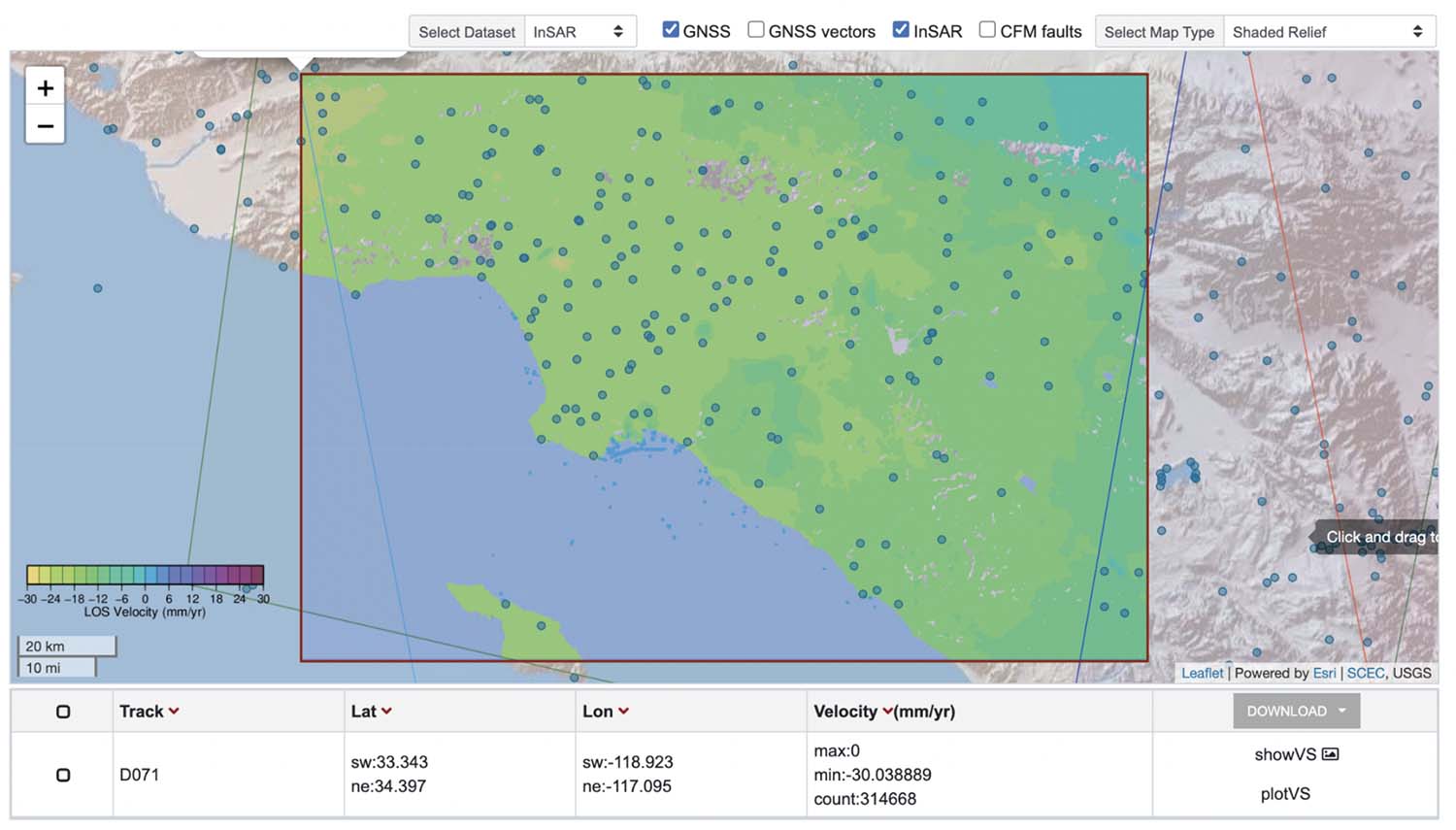 |
| Figure 1: The InSAR and GNSS CGM velocity models, as shown in the CGM web viewer. Blue circles represent the locations of the continuously-recording GNSS stations. The InSAR velocities are in the descending line of sight. |
This first session of presentations was motivated to explore the cuing edge research being done, mostly by scientists not involved in the CGM, which may nevertheless be useful for fulfilling CGM goals for the SCEC community. The session was divided into two, with three presentations followed by questions for the presenters and open discussion among the participants.
In the first half, presentations focused on maximizing the information provided by the InSAR technique, using burst overlap and pixel offset tracking techniques to help recover, or at least constrain, additional components of InSAR displacements, which may help achieve a full three-dimensional product. The NASA “OPERA” project was also introduced, whose goals are to produce a large-scale deformation product from InSAR, with which the CGM has many cross-overs and mutual learning, development and implementation potential.
In the second half, an example of large-scale combination of GNSS and InSAR over the Anatolia region was shown as well as a demonstration of the potential of multi-GNSS (not only GPS) data on GNSS products.
Much of the group discussion was centered around adding the full 3-D displacement products from SAR analysis for the future CGM, using such techniques with Sentinel-1 data and data from other satellites such as ALOS-2. The discussion also recommended that decomposition of CGM InSAR v2 products from line-of-sight (LOS) to a horizontal and vertical component would aid visualization and utility, even if it is less accurate due to assumptions.
Session 3: CGM Products Demonstration and Testing
The last session on the first day of the workshop was focused on the demonstration and testing of the currently available CGM products. Here, we introduced the community to the current CGM model and documentation, showed our potential users how to download data using the web viewer, explained the file formats that we have implemented or designed, and illustrated the use of open-source tools provided by Kathryn Materna for extracting and visualizing CGM data (e.g. https://github.com/kmaterna/InSAR_CGM_readers_writers).
A significant update to product access is a web viewer that now includes the InSAR consensus model as well as GNSS, as shown in Figure 1, above. We asked the community to explore the products and tools we have demonstrated through the CGM Web Viewer, and to be prepared to provide feedback in the breakout sessions the following morning. Other demonstration material, including the documentation, was made available. We also provided participants with an online form to provide feedback on the products demonstrated.
Session 4: CGM Design and Usability
After the introduction of the current products and web viewer to the community the previous day, we held breakout sessions at the start of the second day to allow discussion in more focused groups, including. This is where the majority of the future plans and action items, provided later in this report, were discussed and recorded. Three main breakout groups were formed: one for GNSS, one for InSAR and one for general user and web viewer discussion. After 25 minutes, all participants were encouraged to enter a different breakout session if they wished, to ensure that those who had interests in more than one topic could contribute accordingly.
Session 5: CGM Use Cases and Applications
The second presentation session of the workshop was focused on exploring the possible use cases and applications of the CGM. There were four presentations, covering vertical signals and surface loading, geodetic data contributions to seismic hazard analysis, and monitoring of infrastructure and urban environments using InSAR, followed by a discussion session. The presentations demonstrated the broad application of rigorous, dense and consistent geodetic products, both in the form of time series and velocities. Questions raised during the discussion guided the CGM Working Group towards some technical questions regarding the consistency of the definition of the reference frame, particularly in the vertical component, and the possibility of generating products with variable spatial resolution in areas of small spatial signals or high displacement gradients, particularly considering how much of an involvement the CGM should have measuring anthropogenic structures.
Session 6: The Future of the Community Geodetic Model
At the start of the final session, moderators and reporters from the previous sessions provided a summary of their presentations and discussions, which are compiled into presentation slides. This prompted open exchange of ideas during a final discussion session, which we describe here before the next section on final recommendations.
The community expressed repeated interest in expanding the coverage of the products beyond southern California to include the whole of the Pacific-North America plate boundary. We also had several international participants who requested that the CGM be extended to their regions, such as the Apennines. While both of these ideas are, of course, ideal and goals, they are beyond the current purview of SCEC and not viable within the one- to two-year timeframe of the “bridge period” given the size of the CGM Working Group and the resources of those who actively contribute to it. However, we did state clearly that the research and approaches developed by and for the CGM are applicable to any region of the world, given community interest, data availability and research resources.
The estimation and propagation of uncertainties is a major issue for both the geodetic experts and the modelers, who rely on data confidence to assess their models. GNSS uncertainties have been well researched and, to a large extent, understood for a long time but InSAR, particularly interseismic InSAR time series, is still developing best practices for the estimation and assignment of uncertainty, towards which the CGM is contributing significantly. Few ideas beyond the current approach of averaging InSAR solutions and using the standard deviation were put forward, although iterative reweighting schemes, towards rigorous combinations in the presence of potentially outlying or systematically inconsistent solutions, were suggested.
Finally, visions of what the CGM ultimately can and should look like were put forward. One idea was a “layered” model, where various contributions to the observed time series and velocities are decomposed into component parts, which can be selected and summed depending on any given user’s research priorities, since “one person’s signal is another person’s noise”. For example, “layers” might constitute (in vague order from most spatially broad and temporally long to most spatially dense and temporally short) interseismic strain rate, transient motions (such as creep episodes), aquifer deformation cycles, atmospheric and tropospheric delay and seasonal loading corrections, etc. Another vision for the CGM is to have it be a simple bridge between other SCEC Community Models (CXMs), particularly the Community Fault Model, which can inform geodetically-constrained strain rates from active faulting, and the Community Rheological Model, for which crustal strain rates are an important input component. Either way, it was recommended to have a clear “roadmap” of tasks and exercises to reach the consensus observational products and derived model, for which we provide our conclusions and ideas from this workshop below.
Outcomes, Guidance for Future Plans and Action Items
Significant outcomes of this workshop were:
- The first distribution of InSAR time series and velocity products to the community, in an HDF5 format with reader tools that have been developed by the CGM Working Group (the HDF5 format for InSAR, in particular, received positive feedback)
- Updates on the status of the operational GNSS time series combination for the CGM
- A demonstration of the new availability to browse and download GNSS and InSAR time series
- and velocity products
- The start of a feedback cycle between product generators and users
Finally, we summarize the feedback that we collected from the community over the course of this workshop, during the sessions described above, as a list of action items that we plan to begin implementing in the coming year and beyond:
- InSAR
- Make full, multi-track combined time series publicly available, including a peer-reviewed publication and DOI for the products to cite when used
- Rigorous expansion of the current products to include realistic uncertainties and post-Ridgecrest time series for modelers
- Expand the purview of the CGM to include more satellite missions and possibly variable (higher) resolution in specialized areas for engineering applications
- GNSS
- Reconciliation of multiple analysis center products, particularly in the vertical component
- Development of a combined survey-and-continuous velocity solution, based on time series and consensus list of discontinuities, with uncertainties that are appropriate for the level of scaer between time series analysis algorithms
- Broader CGM goals and desirables
- Full integration of the InSAR and GNSS velocity and time series products, including decomposition of InSAR into three-dimensional components, to produce derived fields of 3-D displacements, velocities and strain rates
- Continued outreach to potential contributors of geodetic observation products and derived fields
TUESDAY, NOVEMBER 9, 2021
All times below are Pacific Standard Time (PST or UTC-8). Presentation videos and slides may be viewed by clicking the links below. PLEASE NOTE: Files are the author’s property. They may contain unpublished or preliminary information and should only be used while viewing the talk. Only the presentations for which SCEC has received permission to post publicly are included below.
| 09:00 - 10:00 | Session 1: Workshop Overview and State of the SCEC CGM Moderators/Reporters: Mike Floyd and Katia Tymofyeyeva |
|
| 09:00 - 09:10 | State of the Community Geodetic Model (VIDEO, PDF) | Mike Floyd, Katia Tymofyeyeva |
| 09:10 - 09:20 | Summary of GNSS products | Mike Floyd |
| 09:20 - 09:30 | Summary of InSAR products | Katia Tymofyeyeva |
| 09:30 - 10:00 | Group Discussion | All |
| 10:00 - 11:00 | Session 2: Research Frontiers Relevant to CGM Moderators: Niloufar Abolfathian and David Bekaert Reporters: Eric Fielding and Gareth Funning |
|
| 10:00 - 10:10 | Interseismic Deformation From Sentinel-1 Burst-Overlap Interferometry: Application to the Southern Dead Sea Fault (VIDEO) | Sjonni Jonsson / Xing Li |
| 10:10 - 10:20 | Tectonic Displacement Mapping from SAR Offset Time Series: Noise Reduction and Uncertainty Quantification | Yunjun Zhang |
| 10:20 - 10:30 | Introduction to the OPERA project and its forthcoming remote sensing products | David Bekaert |
| 10:30 - 10:50 | Group Discussion | All |
| 10:50 - 11:10 | Break | |
| 11:10 - 11:20 | Geodetic surface velocities, strain rates, and seismic hazard estimates for Anatolia and the Alpine-Himalayan belt: recent progress and new applications (VIDEO) | Jonathan Weiss |
| 11:20 - 11:30 | On closure phase and systematic bias in multi-looked SAR interferometry (VIDEO) | Yujie Zheng |
| 11:30 - 11:40 | Multi-GNSS Operations and Research at JPL (VIDEO) | Angelyn Moore |
| 11:40 - 12:00 | Group Discussion | All |
| 12:00 - 13:00 | Session 3: CGM Products Demonstration and Testing | |
| 12:00 - 12:20 | Demo #1: SCEC CGM Web Viewer (see beta version) | Mike Floyd |
| 12:20 - 12:40 | Demo #2: InSAR Products (download Jupyter Notebook and documentation) | Kathryn Materna |
| 12:40 - 13:00 | Group Discussion | All |
| 13:00 | Adjourn Day 1 | |
|
WEDNESDAY, NOVEMBER 10, 2021 |
||
| 09:00 - 10:00 | Session 4: CGM Design and Usability Moderators: Mike Floyd, Katia Tymofyeyeva, and Kathryn Materna Reporter: Kang Wang |
|
| 09:00 - 09:50 | Breakout Sessions (participants self-select breakout)
|
All |
| 09:50 - 10:00 | Group Discussion | All |
| 10:00 - 10:15 | Break | |
| 10:15 - 11:30 | Session 5: CGM Use Cases and Applications Moderator: Xiaohua Xu / Reporter: Junle Jiang |
|
| 10:15 - 10:25 | Displacements of Earth’s surface produced by changes in atmosphere and water (VIDEO) | Donald Argus |
| 10:25 - 10:35 | Contributions of Geodetic Observations and Models to the 2023 Update to the National Seismic Hazard Model (VIDEO) | Fred Pollitz |
| 10:35 - 10:45 | Interferometric Synthetic Aperture RADAR monitoring of infrastructure assets | Pietro Millilo |
| 10:45 - 10:55 | Urban Geodesy: InSAR and GNSS monitoring of urban subsidence, building stability, and infrastructure (VIDEO) | Shimon Wdowinski |
| 10:55 - 11:30 | Group Discussion | All |
| 11:30 - 11:45 | Break | |
| 11:45 - 13:00 | Session 6: The Future of the Community Geodetic Model Moderator: Sylvain Barbot / Reporter: Carla Braitenberg |
|
| 11:45 - 12:10 | Community Feedback: Summaries from Session and Breakout Reporters (PDF) | All |
| 12:10 - 12:35 | Group Discussion: Preferred Products and Grid Resolutions | All |
| 12:35 - 13:00 | Group Discussion: Recommendations for Future Research | All |
| 13:00 | Adjourn Day 2 | |
It is SCEC policy to foster harassment-free environments wherever our science is conducted. By accepting an invitation to participate in a SCEC-supported event, by email or online registration, participants agree to abide by the SCEC Activities Code of Conduct.
PARTICIPANTS
Dimitrios Anastasiou (Nat'l Obs of Athens)
Don Argus (JPL)
Sylvain Barbot (USC)
Marco Bartola (Trieste)
David Bekaert (JPL)
Grant Block (U of New Mexico)
Yehuda Bock (UCSD)
Carla Braitenberg (Trieste)
Roland Burgmann (UC Berkeley)
Andrea Donnellan (JPL)
Noha Farghal (Moody's)
Eric Fielding (JPL-Caltech)
Michael Floyd (MIT)
Gareth Funning (UCR)
Athanassios Ganas (Nat'l Obs of Athens)
Saeed Gorzi Zanjani
Katherine Guns (UCSD/SIO)
Bill Hammond (UNR)
William Holt (Stony Brook U)
Tran Huynh (USC/SCEC)
Muhammad Tahir Javed (Trieste)
Devanshu Jha (MVJCE)
Junle Jiang (U of Oklahoma)
Christopher Johnson (LANL)
Mir Karim (John Tuners Consult)
Jey Kim (Stony Brook U)
Corné Kreemer (UNR)
Xinnan Li (Nanyang Tech)
Xing Li (KAUST)
Danielle Lindsay (UC Berkeley)
Zhen Liu (JPL/Caltech)
Yuan-Kai Liu (Caltech)
Rowena Lohman (Cornell U.)
Kuo-Fong Ma (Academia Sinica)
Philip Maechling (SCEC)
Shujuan Mao (MIT)
Scott Marshall (App State)
Kathryn Materna (USGS)
Pietro Milillo (U of Houston)
Mohammad Mohseni Aref (Potsdam U)
Angelyn Moore (JPL/Caltech)
Jessica Murray (USGS)
Justine Overacker (UNR)
Edric Pauk (USC/SCEC)
Fred Pollitz (USGS)
Alba Rodriguez Padilla (UC Davis)
Chris Rollins (GNS Science)
Mousumi Roy (U of New Mexico)
David Sandwell (UCSD)
Simran Sangha (JPL/Caltech)
Paul Segall (Stanford)
Daya Shanker (IIT Roorkee)
Zheng-Kang Shen (UCLA)
Ramesh Singh (Chapman U)
Krittanon Sirorattanakul (Caltech)
Richard Styron (Global EQ Model)
Mei-Hui Su (USC/SCEC)
Oo Than (Myanmar MoT)
Chia-Hsin Tsai (U of Oxford)
Katia Tymofyeyeva (JPL)
Kang Wang (UC Berkeley)
Shimon Wdowinski (FIU)
Jonathan Weiss (NOAA / U. Hawaii)
Xiaohua Xu (U of Texas)
Yuehua Zeng (USGS)
Yunjun Zhang (Caltech)
Yujie Zheng (Caltech)


