Using Ground Penetrating Radar and Magnetic Gradiometry to Detect Archaeological Artifacts from the San Salvador Settlement in Colton, California, buried during the Santa Ana River’s Great Flood of 1862
Oscar Prado, Chloe S. Sutkowski, Veronica Hernandez, & Jascha PoletPublished August 11, 2019, SCEC Contribution #9420, 2019 SCEC Annual Meeting Poster #122 (PDF)
Poster Image:
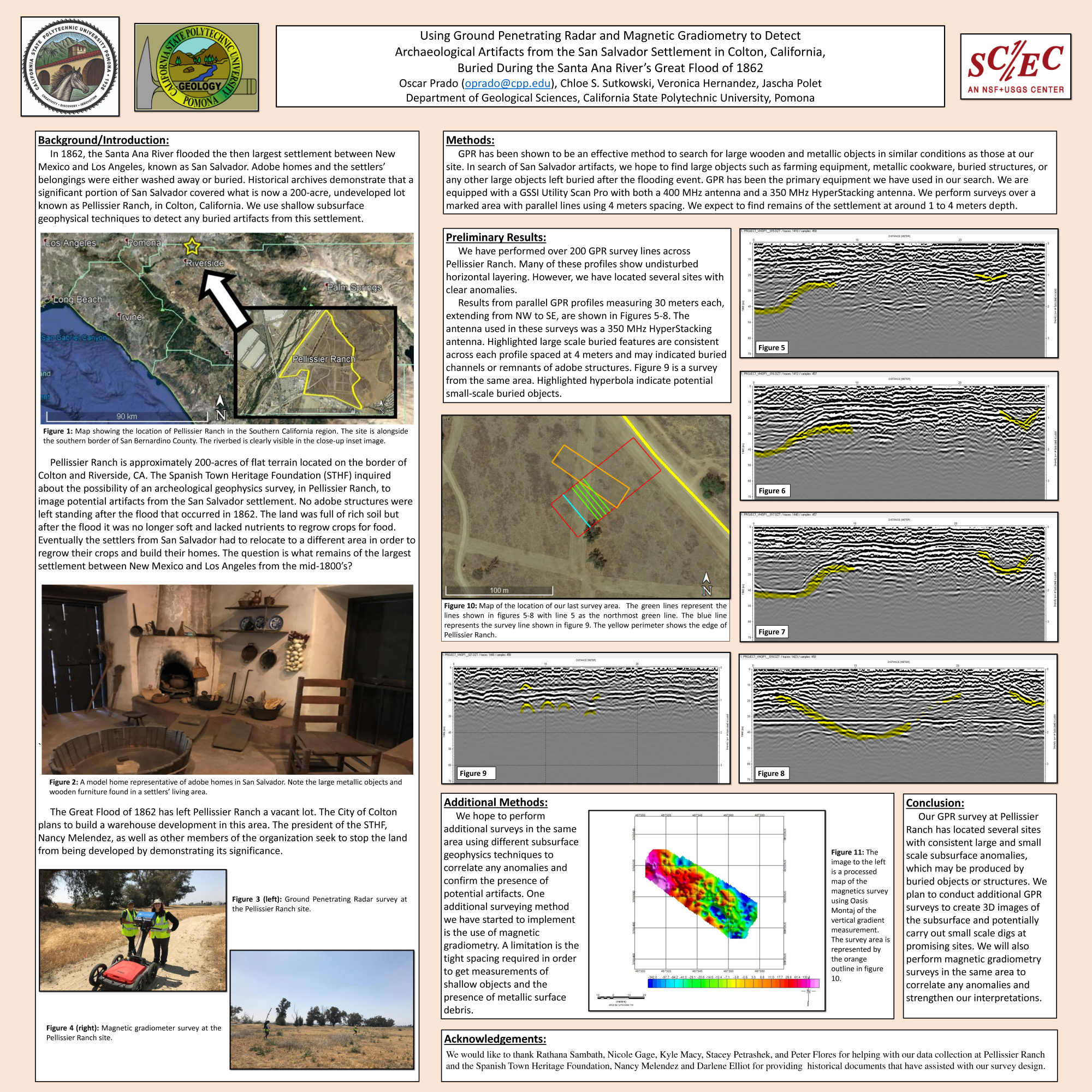
In our non-invasive archeo-geophysical surveys, we use Ground Penetrating Radar (GPR) and magnetic gradiometry. GPR is known to be effective at detecting objects such as buried adobe structures, foundations, wooden fixtures, canals, and metallic items within our expected depth range of 5 meters. Moreover, magnetic gradiometry surveys with short spacing allow us to detect and image large metallic objects. An unavoidable challenge at the site is contemporary debris found at shallow depths and on the surface from trespassers. Therefore, we focus more heavily on our GPR data, but include the gradiometry data across the site to support our interpretations.
We conduct our GPR surveys with a GSSI SIR 4000 control unit equipped with a 350 MHz HyperStacking antenna rated effective at depths down to 10 meters and a 400 MHz antenna effective at depths down to 4 meters. Collected data from the 400 MHz antenna has successfully imaged features in the subsurface that we speculate to be channels and a buried structure. The magnetic gradiometry survey has provided us with a clear change in the properties across a small area, but more extensive surveying across a larger area is planned. We also plan on surveying a larger area in the near future with the 350 MHz HyperStacking antenna. The ultimate goal of our archeo-geophysics research is to provide data to the Spanish Town Heritage Foundation, which could potentially lead to the recognition of the cultural importance of this site.
Key Words
Ground Penetrating Radar, Magnetic Gradiometry, Archaeological Artifacts
Citation
Prado, O., Sutkowski, C. S., Hernandez, V., & Polet, J. (2019, 08). Using Ground Penetrating Radar and Magnetic Gradiometry to Detect Archaeological Artifacts from the San Salvador Settlement in Colton, California, buried during the Santa Ana River’s Great Flood of 1862. Poster Presentation at 2019 SCEC Annual Meeting.
Related Projects & Working Groups
Earthquake Geology


