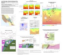
Loma Prieta Again: Subsurface Geology and the San Andreas Fault, Santa Cruz Mountains, Central California
Gary S. Fuis, Rufus D. Catchings, Daniel S. Scheirer, Klaus Bauer, Mark R. Goldman, Tait E. Earney, Guoqing Lin, & Edward ZhangSubmitted September 11, 2022, SCEC Contribution #12084, 2022 SCEC Annual Meeting Poster #250 (PDF)
The 1989 Mw 6.9 Loma Prieta earthquake is the first major event to occur along the San Andreas fault (SAF) zone in central California since the 1906 M 7.9 San Francisco earthquake. Given the complexity of this event, uncertainty has persisted as to whether this earthquake ruptured the SAF itself or a secondary fault. Recent work on the SAF in the Coachella Valley, in southern California, has revealed similar complexity, arising from a non-planar, non-vertical fault geometry, and has led us to re-examine the Loma Prieta event. We have compiled data sets and data analyses in the vicinity of the Loma Prieta earthquake including the 3-D seismic-velocity model and aftershock relocations of Lin and Thurber (2012), potential-field data collected by the U.S. Geological Survey (USGS) following the earthquake, and seismic refraction and reflection data from the 1991 profile of Catchings et al. (2004). The seismic-velocity model and aftershock relocations of Lin and Thurber (2012) reveal a geometry for the SAF that appears similar to that in the Coachella Valley (although rotated 180 degrees): at Loma Prieta the fault dips steeply near the surface and curves with depth to join the moderately southwest-dipping main rupture below 6-km depth, itself also non-planar. The SAF is a clear seismic-velocity boundary, with higher velocities on the northeast, attributable to Mesozoic accretionary and other rocks, and lower velocities on the southwest, attributable to Cenozoic sedimentary and volcanic rocks of the La Honda block. Rocks of the La Honda block have been offset right-laterally hundreds of kilometers from similar rocks in the southern San Joaquin Valley and vicinity, providing evidence that the curved northeast fault boundary of this block is the plate boundary. Thus, we interpret that the Loma Prieta earthquake occurred on the SAF and not on a secondary fault.
Key Words
San Andreas fault, Loma Prieta, non-vertical/non-planar fault
Citation
Fuis, G. S., Catchings, R. D., Scheirer, D. S., Bauer, K., Goldman, M. R., Earney, T. E., Lin, G., & Zhang, E. (2022, 09). Loma Prieta Again: Subsurface Geology and the San Andreas Fault, Santa Cruz Mountains, Central California. Poster Presentation at 2022 SCEC Annual Meeting.
Related Projects & Working Groups
San Andreas Fault System (SAFS)


