| 2010 Research Projects |
|
GPS Monitoring of San Andreas Fault 2010
|
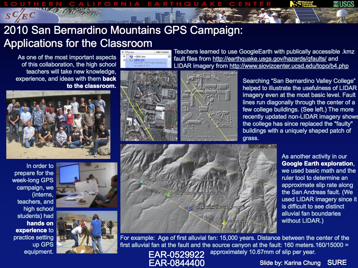
Project Description: Two interns are needed to collect GPS data at various locations in the San Bernardino Mountains, Riverside/San Bernardino Valley and high desert areas. The goal of this project is to monitor elastic strain accumulation in the vicinity of the San Andreas fault. The interns will travel throughout the San Bernardino Mountains and surrounding valleys to set up GPS equipment and monitor it throughout the day. Many of the sites are remote and will require strenuous hiking, carrying the GPS equipment as well as batteries or a solar panel. Some sites will require car camping. The interns should be in good physical condition and should enjoy hiking. The intern will have access to CSUSB’s 4WD vehicle (if they have a valid CALIFORNIA driver’s license), or may be reimbursed for mileage on their own vehicles. There will be a 6-day intensive data collection campaign from Friday June 25 through Wednesday June 30, during which GPS data will be collected from numerous sites simultaneously. This will be preceded by training sessions on June 23 and 24. During the remainder of July and early August the interns will collect GPS data at other sites that were not observed during the primary campaign. Interns will also learn how to interpret GPS time series from previously collected data and to conduct one-dimensional elastic modeling of GPS date for fault slip rates in southern California. For interns who do not live within easy commuting distance of San Bernardino I will post an email announcement on our campus email soliciting faculty and staff who have a room to rent. Interns will pay for rent and other living expenses out of their stipend.
Intern(s): Karina Chung, Mark Swift, Brian Anderson, John Duncan
Mentor(s):
Sally McGill, California State University, San Bernardino
|


Click here for Project pt. 1
Click here for Project pt. 2 |
|
A GPS Resurvey of the Northern San Jacinto Fault: Slip Rates and Seismic Hazards
|
Project Description: The proposed project is for a GPS resurvey of geodetic benchmarks surrounding the San Jacinto valley and Anza segments of the San Jacinto fault, in order to better determine the rate of movement of the fault. The northern San Jacinto fault is currently considered the second most likely to sustain a major (magnitude > 6.5) earthquake in southern California; this project would assist significantly our understanding of the likely seismic hazard, and place constraints on future seismic hazard models. All of the sites to be surveyed are located within a short driving distance of the host institution, UCR. The successful candidate will be responsible for planning of, obtaining permitting for and conducting the survey, as well as updating site descriptions, processing, analyzing and archiving the data. Simple 2D and 3D elastic dislocation models will be used to estimate the slip rate for the fault, and how it may vary along-strike. Full training in the operation of the GPS equipment, GPS data processing and modeling of the data will be provided. The project would be ideal for candidates with some scientific computing skills who are interested in fieldwork. Some background in geology is desirable, but not essential.
Intern(s): Sarah Morton
Mentor(s):
Gareth Funning, University of California, Riverside
Michael Floyd, Massachusetts Institute of Technology
|

Click here for Morton's Project |
|
The SCEC Borehole Instrumentation Program: Web-based Data Search and Dissemination
|
Project Description: The SCEC borehole instrumentation program is a data gathering effort that coordinates making seismic observations from instruments located within boreholes in southern California. Recently a web-based data dissemination portal has been developed to facilitate easier access to this particular subset of seismic data. This project would utilize 1-2 undergraduate researchers to assist with the ongoing integration of the SCEC borehole data into this new web-portal. The students would be using the Antelope software package and custom scripts to process data and metadata from the SCEC borehole stations. Depending on level of expertise, some web programming may also be part of the project.
Intern(s): Karl Harris
Mentor(s):
Jamison Steidl, University of California, Santa Barbara
Sandy Seale, University of California Santa barbara
Francesco Civilini, University of California, Santa Barbara
Hank Ratzesberger, Interpublic Group
Paul Hegarty, University of California, Santa Barbara
|

Click here for Harris's Project |
|
The Growth and Death of Faults
|
Project Description: Geologic evidence suggests that active fault traces are not fixed features; new fault segments develop and some active segments shut down. Within Southern California, shifts in active fault configuration have been linked to long term tectonic changes, such as the transition from Miocene extension to present-day transpression (e.g. Wright). Even within the past 500k years, the geometry of active faults in areas such as the San Gorgonio Pass as shifted (e.g., Matti and Morton, 1993). For example, the geologic evidence suggests that the kinked Mission Creek fault segment was abandoned for the straighter Mill Creek segment around 250 kya (Matti and Morton, 1993). On even shorter time spans, the 1991 Lander’s earthquake shows evidence of rupture along new fault segments that link previous separate offset faults. This project explores how fault segments can be abandoned and new segments grow within analog table top experiments. The experiments use wet clay as an analog for crustal materials. A kinked fault is cut into the clay cake and then electric motors controlled by a computer load the clay box in shear. With a laser scanner we are able to extract quantitative information about the distribution of shear through the clay cake as fault segments are abandoned and new segments grow. So essentially, we watch faults die and get born in our lab.
Intern(s): Jessica Moody
Mentor(s):
Michele Cooke, University of Massachusetts, Amherst
Mariel Schottenfeld, Graduate student
Justin Herbert, Graduate student
|
 |
|
Continuing Study of Tremor in Southern California
|
Project Description: Deep “non-volcanic” tremor and episodic slow-slip events are among the most interesting discoveries in earthquake seismology in the last decade. These events have much longer source durations than regular earthquakes, and are generally located near or below the seismogenic zone where regular earthquakes occur. Tremor and slow-slip events have been found at many places in the circum-Pacific subduction zones, and along the San Andreas fault in central California. Systematic studies of tremor and slow-slip events could lead to a more complete picture of how faults slip and release tectonic stresses, which is critical for understanding earthquake physics and evaluating seismic hazard. Recently both triggered and regular tremor has been found in southern California along the San Jacinto Fault near Anza. However, the newly identified tremor in southern California appears to be less active as compared with those in central California. It is still not clear whether this is due to different quality of seismic instrumentation, or caused by inherent difference in the tremor activity in these regions. We plan to involve an undergraduate intern to continue our study of tremor in southern California. In particular, the intern will learn how to download and organize seismic data, and assist in identifying low-frequency earthquakes within triggered and regular tremor in this region. The obtained results would be useful for better understanding the necessary conditions for tremor occurrence, and the relationship between tremor and earthquakes and faults in southern California.
Intern(s): Adrian Doran
Mentor(s):
Zhigang Peng, Georgia Institute of Technology
Kevin Chao, Graduate student
|

 |
|
CISN ShakeAlert: Towards a Prototype Earthquake Early Warning System for California
|
Project Description: Earthquake early warning (EEW) requires fast and robust predictions of earthquake source and ground motion parameters shortly after the initiation of an earthquake. If given in a timely manner, warnings can be used to trigger and execute automatic measures to reduce expected damage at distant sites. Over the past three years the California Integrated Seismic Network (CISN) has tested the real-time performance of three algorithms for providing EEW in California: the single-sensor based τc-Pd on-site and the network-based (2) ElarmS, and the (3) Virtual Seismologist (VS) algorithms. The algorithms have successfully detected many earthquakes and in some cases predicted the peak ground shaking a few seconds before it was felt. In the next three years we plan to migrate from three semi-parallel processing threads to a single integrated system, called CISN ShakeAlert. This prototype thread will provide a continuum of earthquake alert information that will be passed to a small group of collaborating test users to develop procedures and formats that could be used in a complete end-to-end prototype warning system in the future. We are seeking for a curious and motivated student who will be involved in the development and optimization of the CISN ShakeAlert system, including, e.g., the estimation of the system performance during several possible earthquake scenarios in Southern and Northern California, considering, e.g., the available warning times, uncertainties in the predicted source and ground motion parameters and finite fault effects during large earthquakes. The successful candidate may also assist us in developing a user display for visualizing information and warnings provided by the ShakeAlert system, or analyze and optimize the performance of single-sensor based algorithms for EEW.
Intern(s): Magali Barba
Mentor(s):
Maren Boese, California Institute of Technology
Egill Hauksson, California Institute of Technology
|

Click here for Barba's Project |
|
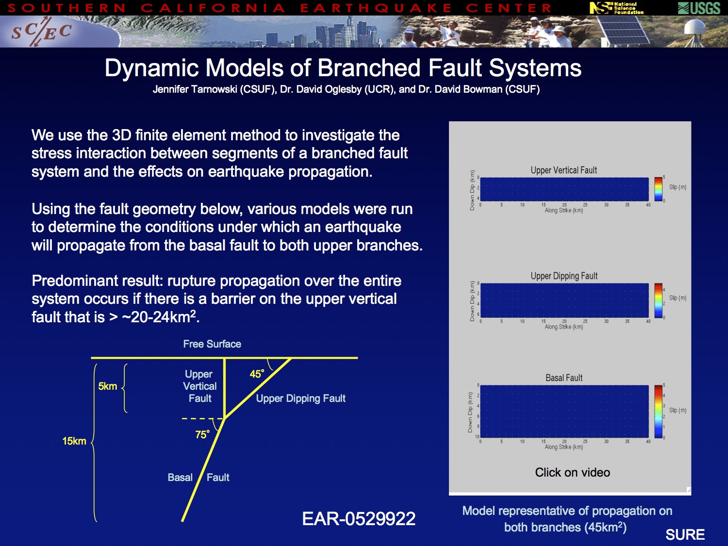
The Dynamics of Complex Fault Branches: Continued Collaboration Between UC Riverside and Cal State Fullerton
|
Project Description: Students participating in this project will work with Faculty at UC Riverside and Cal State Fullerton to model the dynamics of branched faults under realistic (and complex) modeling assumptions. The SCEC intern will construct, run, and analyze numerical models under a variety of assumptions about fault geometry and material properties. In spite of their cutting-edge nature, these models should be accessible to a motivated and technically competent undergraduate in the physical sciences. We plan to investigate the dynamics of fault systems such as
- Multiple (i.e., > 3) fault branches intersecting at a single point—which path is most likely, and how does rupture on one segment affect slip on neighboring segments? A 2D parameter study may be appropriate in this case.
- Fault branches that are separated by varying gaps—is the most likely branch the same if a gap is present for all branch segments?
- Fault branches where there is a damage zone in or near the branch region.
- Slip partitioning in thrust systems rather than oblique-normal systems, where the increments of normal stress change are of opposite sign.
In all cases, we will compare our results with similar observed fault systems in nature. This is part of a long-term collaboration between UCR & CSUF involving SCEC Interns.
Intern(s): Jennifer Tarnowski
Mentor(s):
David Oglesby, University of California, Riverside
David Bowman, California State University, Fullerton
|
 |
|
Do Earthquakes on Large Strike-Slip Faults Follow a Gutenberg Richter Distribution?
|
Project Description: We address the important question of the magnitude-frequency distribution for large strike-slip faults. Some recent studies have argued in favor of Gutenberg-Richter distribution, while others have argued for statistics that favor large earthquakes of a characteristic size. In an initial examination of this question, we considered the century-long instrumental catalog of earthquakes for two large strike-slip faults that ruptured along most of their length during the 20th century: the Queen Charlotte-Fairweather Fault in western Canada and southeastern Alaska, and the North Anatolian Fault in Turkey. For each of these faults, we analyzed the available earthquake catalogs, took into consideration their detection thresholds, and tested the confidence with which the observed earthquake activity could be considered a realization of a Gutenberg-Richter distribution using the Kolmogorov-Smirnoff test on the cumulative distributions. The relatively inaccurate locations in both areas prevent us from restricting our analysis to earthquakes on the fault itself. Instead, we were forced to consider earthquakes from a band of substantial width (~100 km) astride the fault. We tested over a range of possible b-values to construct a 95% confidence interval bounding an area believed to contain the true b-value if one exists. We found that in both cases the seismicity could be considered a realization of a Gutenberg-Richter distribution. The confidence interval for the Queen Charlotte region spans a b-value range of 0.5-0.63 and for the North Anatolian Fault spans 0.54-0.88. However, the near total lack of moderate earthquakes along the rupture zones of the M 7-8 events suggests that the Gutenberg-Richter distribution may not accurately characterize the size distribution of earthquakes on individual faults.
Intern(s): Samuel Bydlon
Mentor(s):
Gregory Beroza, Stanford University
|

Click here for Bydlon's Project pt. 1
Click here for Bydlon's Project pt. 2 |
|
The 2010 Ocotillo Swarm: Preliminary Results from Data Recorded at the NEES@UCSB Wildlife Liquefaction Array
|
Project Description: On 15 June 2010 at 9:26 PM PDT a Mw 5.7 event occurred 7.7 km ESE of Ocotillo, CA. This event is considered to be the largest aftershock to date of the 4 April 2010 M 7.2 Sierra el Mayor earthquake. The Ocotillo event generated its own series of local aftershocks. The NEES@UCSB Wildlife Liquefaction Array (WLA) in the Imperial Basin is located 57 km NE of the Ocotillo event. Since June 15th, hundreds of aftershocks have been recorded at WLA. The events were recorded by three-component strong-motion accelerometers at the surface and in boreholes at various depths. A significant number of these events have magnitude 3.0 and above. As of August 15th, 72 aftershocks greater than M 3.0 were recorded at WLA. From this unique set of recordings, we have selected 60 events with good signal-to-noise ratio for our study. Of these 60, 25 have M 3.5 and above. Our study examines data recorded by the surface instrument and instruments located in the boreholes. We present a spectral analysis of the main shock compared with the average spectrum of the suite of 60 aftershocks and the average spectrum of the subset of 25 larger aftershocks. We also present spectral ratios of surface to downhole recordings for the main shock and the aftershock data. Consistency of source mechanism is clearly evident in the various spectra plotted for the three components of motion. Our study is ongoing and will incorporate future aftershocks of the Ocotillo event.
Intern(s): Daniel Huthsing
Mentor(s):
Jamison Steidl, University of California, Santa Barbara
Sandy Seale, University of California, Riverside
|

Click here for Huthsing's Project |
|
The Impact of the Earthquake Country Alliance Earthquake Education and Public Information Centers (ECA EPIcenters)
|
Project Description: The Earthquake Education and Public Information Center (EPIcenter) Network shares a commitment to encouraging earthquake preparedness through demonstrated leadership in risk-reduction and earthquake education. The EPIcenter Network, starting as an informal alliance in 2008, is now comprised of over 55 free-choice learning institutions throughout California and elsewhere. Having demonstrated its viability, the Network is building a strategy for sustainability. The purpose of the research is to develop impact measures for the EPIcenter Network through grounded theory. Five Network members were interviewed to further understand their institution’s goals and mission. The data were incorporated into 5 logic models, one for each institution. The logic models illustrate how the mission of the EPIcenter Network supports the mission of each institution. The models also show the theoretical outcomes and impact of the Network on each institution and the Network on the communities served by each institution. Although there were differences in inputs and outputs between types of free-choice learning institutions, the theoretical outcomes were similar. The five logic models represent a single focused initiative to measure the impact of the EPIcenter Network. A continued literature review on informal science learning and evaluation methods, increased communication with members of the Network, and increased data collection are needed to continue the impact measurement and development of the EPIcenter Network. A potential product of this research is a rubric that will allow individual institutions and the EPIcenter Network as a whole to measure success and identify areas of improvement.
Intern(s): Irene Gow
Mentor(s):
Robert de Groot, University of Southern California
|

Click here for Gow's Project |
|
SCEC Educational Products and Programs
|
Project Description: To promote improved earthquake awareness and preparedness the SCEC Communication, Education, and Outreach program developed the ShakeOut Curriculum and the Take on the Quake Program. This research project continues the development and refinement of these resources. The ShakeOut Curriculum activities were designed to be used leading up to and after the ShakeOut drill. Significant enhancements to this product included expanding the module from six to ten lessons, the development of a facilitator guide with background information, teaching tips, and suggestions for effective implementation with a variety of learners. Other improvements included aligning the lessons with California Science Content Standards and the National Science Education Standards, making the lessons more inquiry-based, and modifying the overall organization of the curriculum. The Take on the Quake Program is ideal for use in many free-choice learning environments such as museums, scouting, after-school programs, libraries, and in parks. Depending on the time available for instruction the program facilitator may select one of three options: Express (45 minutes), Explore (1 hour, 15 minutes) and Experience (2 hours). Take on the Quake was improved through the development of a facilitator guide and further development of the activities. For both the ShakeOut Curriculum and the Take on the Quake Program special attention was devoted to minimizing the need for consumables allowing for cost-effective implementation while also fostering sustainability. Both products are aligned with Earthquake Country Alliance mission by fostering a culture of earthquake and tsunami readiness in California.
Intern(s): Yessenia Robles
Mentor(s):
Robert de Groot, University of Southern California
|

Click here for Robles's Project |
|
Prehistoric Earthquakes Along the San Jacinto Fault in Trench 7 at the Mystic Lake Paleoseismic Site
|
Project Description: Mystic Lake occupies a closed depression in the San Jacinto Valley within a releasing step-over between the Casa Loma and Claremont faults in the San Jacinto fault zone. In July 2010 we excavated three new trenches (T5, T6 and T7) across the Claremont fault within the deposits of Mystic Lake near the northwestern end of this step-over. This poster presents results from Trench 7, located 5-10 meters northwest of the original trench (T1), which was excavated in October 2009. Six prehistoric faulting events were identified in Trench 1 over the past 1600 years. In Trench 7 we were able to confirm Event 2 at the same stratigraphic level as in Trench 1, based on a pronounced angular unconformity and a buried graben. Trench 7 also contained evidence (a package of beds thinning against an inferred fold scarp) consistent with an earthquake at the level of Event 3 in Trench 1. Numerous cracks also extended above the Event 2 horizon to the base of a historically deposited layer that contained a tin can (in Trench 1). Stratigraphy was poor in this part of the section, but two white silt layers within 10 cm below the lowest historic deposit were disrupted within the fault zone. This disruption appears to be at a higher stratigraphic level than Event 1 in Trench 1, but additional work will be necessary to test whether this really represents an additional earthquake that was not recognized in Trench 1. As in Trench 1, there are also a few faults that extend to the ground surface, vertically displacing the historical layers by a cm or two. The lack of historical earthquakes along this portion of the fault, however, suggests that these small offsets are probably due to groundwater withdrawal or creep rather than being related to earthquakes. Approximately fifty charcoal samples were taken from Trench 7, including samples from most exposed units. In particular, samples from units 390 and 400 in Trench 7 will allow us to bracket the age of event 3, which was not directly datable in Trench 1.
Intern(s): Jamie Bywater
Mentor(s):
Sally McGill, California State University, San Bernardino
|

Click here for Bywater's Project pt. 1
Click here for Bywater's Project pt. 2 |
|
Innovative Representation of Earthquake Triggering from Sonification/Visualization of Seismic Signals
|
Project Description: Sonification of seismic data is an innovative way to represent seismic data in the audible range (Simpson, 2005). Seismic waves with different frequency and temporal characteristics, such as those from teleseismic earthquakes, deep “non-volcanic” tremor and local earthquakes, can be easily discriminated when time-compressed to the audio range. Hence, sonification is particularly useful for presenting complicated seismic signals with multiple sources, such as aftershocks within the coda of large earthquakes, and remote triggering of earthquakes and tremor by large teleseismic earthquakes. Previous studies mostly focused on converting the seismic data into audible files by simple time compression or frequency modulation (Simpson et al., 2009). Here we generate animations of the seismic data together with the sounds. We first read seismic data in the SAC format into Matlab, and generate a sequence of image files and an associated.wav sound file. Next, we use a third party video editor, such as the QuickTime Pro, to combine the image sequences and the sound file into an animation. We have applied this simple procedure to generate animations of remotely triggered earthquakes, and tremor and low-frequency earthquakes in California, and mainshock-aftershock sequences in Japan and California. These animations clearly demonstrate the interactions of earthquake sequences and the richness of the seismic data. The tool developed in this study can be easily adapted for use in other research applications and to create sonification/animation of seismic data for education and outreach (E&O) purpose.
Intern(s): Meghan Fisher
Mentor(s):
Zhigang Peng, Georgia Institute of Technology
|

Click here for Fisher's Project |
|
The Shaky Truth: Debunking Doug Copp and the Triangle of Life
|
Project Description: The 'Triangle of Life' theory, advocated by self-proclaimed rescuer Doug Copp, has been in circulation via viral email within the past decade, and it has garnered concerns from many professional disaster organizations about the dangerous recommendations made to the public on the actions to take during an earthquake. This research project was set out to achieve 3 main objectives: to question and refute the validity of Copp’s claims and credentials, to correct widespread misinformation regarding Triangle of Life, and to educate the public on the approved “Drop, Cover and Hold On” method of earthquake response through social media outreach. Initial research consisted of cataloguing Doug Copp’s claims, which ranged from his featured videos about the Triangle of Life, to his supposed health problems complicated by his rescue effort at the site of 9/11. These claims were categorized and cross-referenced with outside responses from various journalistic resources, news media, and individual testimonies, all to create a comprehensive FileMaker database that can eventually be transformed into an online resource for the public in the long run. The research project also consisted of public outreach and communicating the danger of Triangle of Life to bloggers and other web users who have continued the circulation of Doug Copp’s original email. All of these efforts strive for the increase in public knowledge on the Triangle of Life fallacy and the employment of “Drop, Cover and Hold On” as a universal policy for earthquake safety preparedness.
Intern(s): Andy Liang
Mentor(s):
Mark Benthien, University of Southern California
|

Click here for Liang's Project |
|
(no name)
|
Project Description:
Intern(s): Katie Camarda, Nathan Warbuton, Alicia Leslie, Pam Patipanavat, Sabrina Lawrence-Gomez, Lindsay Orr
Mentor(s):
Mark Benthien, University of Southern California
|
|
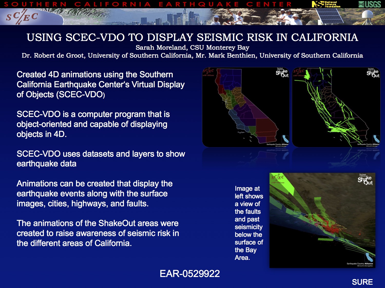
Production of Southern California Earthquake Center Virtual Display of Objects (SCEC-VDO) Displaying Seismic Risk of the Eleven Shakeout Areas Within California
|
Project Description: The Great California ShakeOut began in 2008 as a way to educate the public on earthquake preparedness and emergency management in the event of a large earthquake. In order to implement the drill, California has been divided into eleven regions that have been designated as Shakeout areas. Using the Southern California Earthquake Center Virtual Display of Objects (SCEC-VDO), animations showing the various faults and recorded seismicity have been created for each ShakeOut area. This project developed a suite of 30 second VDOs that focus on each of the eleven areas. SCEC-VDO is an object-oriented, open source software, that enables interactive 4D display of diverse geo-referenced datasets for analysis, presentation, and publication. Examples of datasets that can be visualized using SCEC-VDO include earthquake events, hypocenters and epicenters, fault systems and fault sections, three-dimensional surface images, tectonic plates and their vectors of motion, as well as political boundaries, cities, and highways. SCEC-VDO visualizations were produced to show past events that occurred in each ShakeOut area, and to educate a variety of audiences on probable threats. A second suite of 30 second VDOs is also created to show an event that occurred in one of the ShakeOut areas, the fault it occurred on, and the aftershocks that followed. These were created in an interactive way that allows them to be linked to other VDOs. Working alongside of ShakeOut projects and The Earthquake Country Alliance, SCEC-VDO visualizations are tools which will be used in teaching and spreading the word on earthquake preparedness.
Intern(s): Sarah Moreland
Mentor(s):
Mark Benthien, University of Southern California
Robert de Groot, University of Southern California
|
 Click here for Moreland's Project Click here for Moreland's Project |


