
| PROGRAM | TRAVEL | REGISTRATION | ABSTRACTS | PARTICIPANTS |
Meeting Abstracts
The SCEC collaboration emphasizes the connections between information gathering by sensor networks, fieldwork, and laboratory experiments; knowledge formulation through physics-based, system-level modeling; improved understanding of seismic hazard; and actions to reduce earthquake risk and promote resilience. Use the form below to search and view all poster and invited talk abstracts submitted to this meeting.
| SCEC ID ▲ | Category | Title and Authors | SCEC Award |
|---|---|---|---|
|
Poster 101 |
Geodesy |
Postseismic deformation following the 2013 Mw 7.7 Balochistan (Pakistan) earthquake observed with Sentinel-1 Interferometry
Kang Wang, Yuri Fialko The Mw 7.7 Balochistan earthquake occurred on September 24th, 2013 in southwestern Pakistan. The earthquake rupture was characterized by mostly left-lateral strike slip, with a limited thrust component, on a system of curved, non-vertical (dip angle... more |
|
|
Poster 102 |
Geodesy |
Northwest Propagation of Postseismic Deformation in the Yuha Desert from the 2010 M7.2 El Mayor – Cucapah Earthquake
Andrea Donnellan, Jay Parker, Robert Granat, Michael Heflin, John Rundle, Lisa Grant Ludwig, Marlon Pierce, Jun Wang The 2010 M7.2 El Mayor – Cucapah (EMC) ruptured from Baja California to the US Mexican border, triggering slip on a network of faults, primarily in the northeast lobe of coseismic deformation. Postseismic slip continued to occur on a network of... more |
|
|
Poster 103 |
Geodesy |
Line-of-Sight Velocity Map along the San Andreas Fault System from GPS and Sentinel-1 InSAR: Contribution to the SCEC Community Geodetic Model
Xiaohua Xu, David Sandwell We present a crustal deformation velocity map along the San Andreas Fault System by combining measurements from Sentinel-1 Interferometric Synthetic Aperture Radar (InSAR) and Global Positioning System (GPS) velocity models (CGM V1). We assembled 5... more |
17042
|
|
Poster 104 |
Geodesy |
Integration of InSAR and GPS data for 3-dimensional crustal deformation mapping
Zhen Liu, Zheng-Kang Shen, Cunren Liang, Paul Lundgren GPS and InSAR are complementary to each other for crustal deformation mapping, with the former offering discrete high-fidelity 3-dimensional (3-D) point positioning while the latter providing 2-D dense spatial coverage of deformation measured along... more |
|
|
Poster 105 |
Geodesy |
Toward the 3-component time-dependent Crustal Motion Model: Integration of Sentinel-1 SAR interferometry and continuous GPS
Ekaterina Tymofyeyeva, Yuri Fialko We combined data collected between 2014-2017 by the Sentinel-1 InSAR mission with continuous GPS measurements to calculate the three components of the interseismic surface velocity field in Southern California at the resolution of InSAR data (~100 m... more |
17046
|
|
Poster 106 |
Geodesy |
Characterizing fault motion using edge detection in radar images
Margaret Glasscoe, Jay Parker, Andrea Donnellan A moderate sized or secondary near-surface fault slip appears in a radar interferogram as a roughly linear feature with cross-section resembling either a step function or a Gaussian-filtered step, called a sigmoid. Building on past work that detects... more |
|
|
Poster 107 |
Geodesy |
InSAR coherence time series - soil moisture as a proxy for alluvial fan age?
Rowena Lohman, Chelsea Scott, Teresa Jordan When scientists can determine the ages of surfaces within a tectonically active area, they can turn observations of offsets and deformation into rates, repeat times and evaluations of hazard. Here, we explore the use of InSAR coherence time series... more |
|
|
Poster 108 |
Geodesy |
Towards an Understanding of the Geometry of the Hilton Creek Fault System Within the Long Valley Caldera, Using Ground-Based Magnetics and High-Resolution Topographic Profiles
Jason De Cristofaro, Jascha Polet The eastern escarpment of California’s Sierra Nevada mountains is defined by a series of high-relief down-to-the-East normal faults including the Owens Valley, Round Valley, Hilton Creek and Hartley Springs faults. These faults separate the Sierra... more |
|
|
Poster 109 |
Geology |
Examining earthquake processes with microtextural analysis and (U-Th)/He thermochronometry: a case study from hematite fault mirrors in the Wasatch fault zone
Robert McDermott, Alexis Ault, James Evans Advances in physically based models of earthquake rupture place an increasing importance on characterization of the physical processes that control dynamic friction in natural faults. We apply coupled textural analysis and hematite (U-Th)/He (He)... more |
|
|
Poster 110 |
Geology |
Timing of Earthquakes during the past 800 years along the Peninsula Section of the San Andreas Fault Suggests Persistent 1906-like Behavior
Gordon Seitz, Maxime Mareschal, Nathan Barrett, David Olsen Evidence to support the existence of a peninsula San Andreas fault (SAF) segment, with an individual earthquake (EQ) history, has been a speculative hypothesis. The only historical EQ rupture that can be confidently located, is the M7.9 1906 San... more |
|
|
Poster 111 |
Geology |
Hematite nano- to micro-textures and (U-Th)/He thermochronometry inform seismic and aseismic fault damage zone processes
Alexis Ault, Robert McDermott, Amy Moser, James Evans Hematite fault mirrors and striated, metallic slip surfaces in exhumed fault zones record disparate thermal and mechanical processes. Hematite is amenable to (U-Th)/He (He) dating and accurate interpretation of hematite He data requires hematite... more |
14125, 17164
|
|
Poster 112 |
Geology |
Frictional strengths of fault gouge from a creeping segment of the Bartlett Springs Fault, northern California
Jerlyn Swiatlowski, Diane Moore, David Lockner The Bartlett Springs Fault (BSF) is a right-lateral strike-slip fault that is part of the San Andreas Fault System in Northern California with an estimated slip rate of ~7 mm/yr. Near Lake Pillsbury, the BSF slip rate is expressed as fault creep at... more |
|
|
Poster 113 |
Geology |
Testing the shorter and variable recurrence interval hypothesis along the Cholame segment of the San Andreas Fault
Alana Williams, Ramon Arrowsmith, Thomas Rockwell, Lisa Grant Ludwig, Sinan Akciz, Allen Gontz The Cholame segment of the San Andreas Fault is positioned between the Parkfield and Carrizo segments to the NW and SE, respectively, 20 km southeast of Highway 46. Rupture behavior is poorly characterized for this ~75 km reach, limiting seismic... more |
17017
|
|
Poster 114 |
Geology |
The rock record of seimic nucleation: a case study from the Whipple Mountains Detachment Fault, eastern California
Daniel Ortega-Arroyo, Whitney Behr, Emilie Gentry Despite advances in our understanding of the physics of earthquakes, the mechanisms by which dynamic rupture nucleates in the middle crust remains enigmatic. Proposed mechanisms include flash heating of asperities, thermal pressurization of pore... more |
|
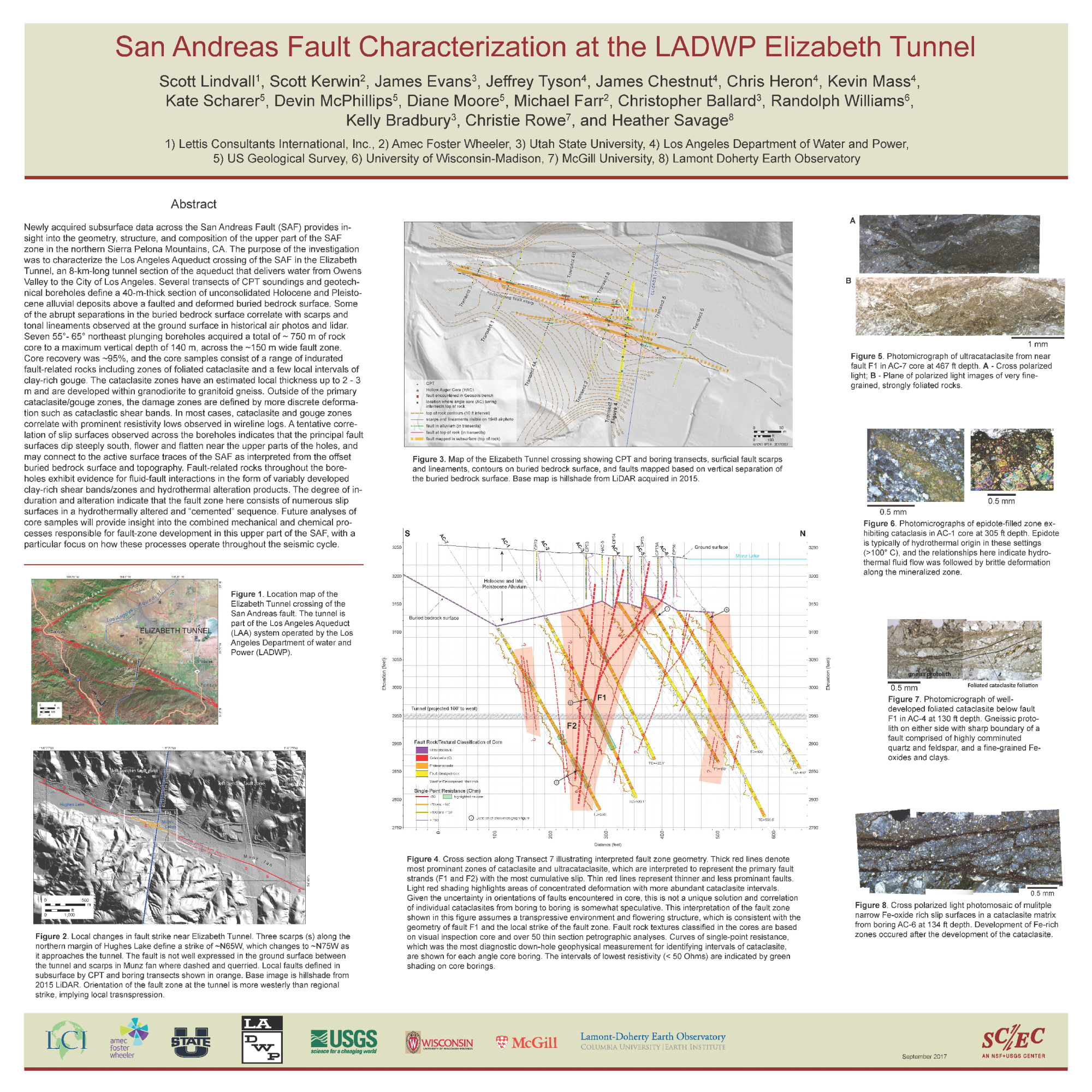 |
Geology |
San Andreas Fault Characterization at the LADWP Elizabeth Tunnel
Scott Lindvall, Scott Kerwin, James Evans, Jeffrey Tyson, James Chestnut, Chris Heron, Kevin Mass, Katherine Scharer, Devin McPhillips, Diane Moore, Michael Farr, Christopher Ballard, Randolph Williams, Kelly Bradbury, Christie Rowe, Heather Savage Newly acquired subsurface data across the San Andreas Fault (SAF) provides insight into the geometry, structure, and composition of the upper part of the SAF zone in the northern Sierra Pelona Mountains, CA. The purpose of the investigation was to... more |
|
|
Poster 116 |
Geology |
Comparison of fault rocks formed paleoseismically and by paleocreep(?): Initial results from the West Salton detachment fault, southern California
Gary Axen, Katrina Soundy, Virgil Leuth The West Salton detachment fault bounds the western Salton Trough (upper plate) above the Peninsular Ranges footwall. 10-15 km of top-E, low-angle normal slip from ~8 Ma to ~1 Ma (during San Andreas plate boundary activity) exhumed the footwall ~5-... more |
17114
|
|
Poster 117 |
Geology |
Geomorphic and geologic evidence for slip along the San Bernardino strand of the San Andreas Fault System through the San Gorgonio Pass structural knot, southern California
Katherine Kendrick, Jonathan Matti The San Gorgonio Pass (SGP) region of southern California represents an extraordinarily complex section of the San Andreas Fault (SAF) zone, often referred to as a structural knot. Complexity is expressed both structurally and geomorphically, and... more |
|
 |
Geology |
Evidence of Na- and Mg-rich Hydrothermal Brines Driving Chloritization and Albitization in an Active Fault Zone: Case Study of the Borrego Fault, Baja CA, Mexico
Matthew Dorsey, Thomas Rockwell, Gary Girty, Giles Ostermeijer, Thomas Mitchell, John Fletcher We collected a continuous sample of the fault core and 23 samples of the fault zone out to 52 m across the rupture trace of the 2010 M7.2 El Mayor-Cucapah earthquake to characterize the physical damage and chemical transformations associated with... more |
|
|
Poster 119 |
Geology |
A new, 170 ka slip rate estimate on the Sierra Madre Fault
Nathaniel Lifton The Sierra Madre fault (SMF) system uplifts the San Gabriel Mountains along the northern Los Angeles metropolitan area. Slip rates on the Central SMF vary from ~3 mm/yr in geodetic studies to ~1 mm/yr in late Quaternary geologic studies. There have... more |
16066
|
|
Poster 120 |
Geology |
Investigating strain transfer along the Southern San Andreas Fault: A geomorphic and geodetic study of block rotation in the Eastern Transverse Ranges, Joshua Tree National Park, CA
Katherine Guns, Richard Bennett, Kimberly Blisniuk To better evaluate the distribution and transfer of strain and slip along the Southern San Andreas Fault (SSAF) zone in the northern Coachella valley in southern California, we integrate geological and geodetic observations to test whether strain is... more |
17161
|
|
Poster 121 |
Geology |
Slip rate variation of the Central Sierra Madre fault, southern California over the past 200 ka
Katherine Scharer, Reed Burgette, Austin Hanson, Nathaniel Lifton, Tammy Rittenour, Devin McPhillips The Central Sierra Madre fault (CSMF) system uplifts the San Gabriel Mountains along the northern Los Angeles metropolitan area. A suite of late Quaternary alluvial fan surfaces are preserved near Arroyo Seco and offset across strands of the CSMF.... more |
15179, 16066
|
|
Poster 122 |
Geology |
Sources and Magnitudes of Uncertainty in Fault Slip Rate, Cucamonga Thrust Fault, Southern California
Devin McPhillips, Katherine Scharer Maps of historic earthquake ground surface ruptures show that displacements along strike are spatially variable. As a result, latest Quaternary slip rates developed from a small number of displacement measurements may not accurately represent fault... more |
|
|
Poster 123 |
Geology |
Structural Architecture of the Western Transverse Ranges and Potential for Large Earthquakes – Trishear Forward Models
Yuval Levy, Thomas Rockwell, John Shaw, Andreas Plesch, Neal Driscoll, Hector Perea Fold-and-thrust belts evolve over time, can produce large-scale faults and potentially accommodate large magnitude earthquakes. The thrust fronts of these structures typically form large fold structures in their hanging walls, and they tend to... more |
16049
|
|
Poster 124 |
Geology |
Strath terraces in the Santa Ynez Valley suggest late Quaternary activity on a detachment fault beneath the Western Transverse Ranges, California
Nate Onderdonk, Andrew Farris, Edward Tyler, Ani Pytlewski, Antonio Garcia, Shannon Mahan High rates of shortening across the western Transverse Ranges (WTR) have been interpreted from geodetic, geologic, and geomorphic data. Studies of active deformation of the WTR have been focused on structures along the Ventura-Santa Barbara coast.... more |
|
|
Poster 125 |
Geology |
New high-resolution seismic data reveals the Holocene active structures and deformation events in offshore Ventura basin, CA
Hector Perea, Gülsen Ucarkus, Neal Driscoll, Graham Kent, Yuval Levy, Thomas Rockwell During the last 2-5 Ma, the Transverse Ranges (Southern California) have been subject to a N-S compression related to the formation of a regional restraining bend in the San Andreas Fault and resulting in the development of an E-W trending thrust-... more |
12026
|
|
Poster 126 |
Geology |
Evidence for Holocene coseismic subsidence during a non- plate boundary earthquake
Laura Reynolds, Alexander Simms, Thomas Rockwell, Yusuke Yokoyama, Yosuke Miyairi, Alexandra Hangsterfer Coseismic subsidence is a coastal hazard commonly associated with subduction zones. Although discrete coseismic events have also been proposed for tectonic basins and synclines along non-plate boundary active margins, confidently differentiating the... more |
14008, 15156, 16132
|
|
Poster 127 |
Geology |
A new estimate of latest Quaternary slip on the offshore Anacapa-Dume Fault at Sycamore Knoll, Southern California Continental Borderland
Ethan Williams, Christopher Castillo, Simon Klemperer, Nicole Raineault, Lind Gee At the boundary between the Western Transverse Ranges province and Inner Continental Borderland of Southern California, strain is partitioned across the sinistral-oblique Anacapa-Dume Fault system. As the offshore continuation of the Santa Monica-... more |
|
|
Poster 128 |
Geology |
Activity and earthquake potential of the Wilmington blind thrust, Los Angeles, CA: The largest earthquake source not on current southern California hazard maps?
Franklin Wolfe, James Dolan, Andreas Plesch, John Shaw The Wilmington blind thrust fault may represent one of the largest deterministic seismic hazards in the United States, in that it extends for more than 30 km along strike beneath the densely populated Los Angeles metropolitan area and the Ports of... more |
|
|
Poster 129 |
Geology |
Can maximum magnitude be derived from fault dimensions?
Debbie Weiser, Natanya Porto, David Jackson Maximum magnitude is an important parameter used in seismic hazard maps and risk assessment. Maximum magnitude is used to define the largest possible earthquake modeled for a specific fault, or for a defined area. To estimate maximum magnitude,... more |
|
|
Poster 130 |
Geology |
A predictive model for earthquake rupture extents given an early warning epicenter
Steven Wesnousky, Glenn Biasi Steps and bends in faults affect the probability that rupture will continue to propagate along a fault. Empirical relationships for rupture through individual step and bend features have been developed through examination of past surface ruptures (... more |
17064
|
|
Poster 131 |
Geology |
Ladders, stair-steps, and crossing faults: Insights from southern California’s active strike-slip faults
Susanne Jänecke, Benjamin Belgarde, Ann Bykerk-Kauffman, James Evans, Stefan Kirby, Daniel Markowski, Alexander Steely, Steve Thornock Detailed mapping and structural analyses of the San Andreas, San Jacinto, Elsinore, and cross faults, southern California, reveals geometries of strike-slip (ss) faults that do not match classic models. Many fault zones exhibit ladder-like... more |
07126, 11164, 12137, 10134
|
|
Poster 132 |
Geology |
Dekameter-scale geologic structure validation of shallow seismic properties along the San Jacinto fault at Sage Brush Flat, Anza, California
Adam Wade, Ramon Arrowsmith, Andrea Donnellan, Frank Vernon, Yehuda Ben-Zion In support of observations and interpretations from the dense seismic array across the San Jacinto Fault Zone (SJFZ), we performed detailed (1:1000-1:2500 scale) mapping, excavation and unmanned aerial vehicle (UAV) data collection at Sage Brush... more |
17805
|
|
Poster 133 |
Geology |
Tectonic control on landsliding in the nepal himalaya revealed by the 2015 gorkha earthquake
Paul Quackenbush, Josh West, Marin Clark, Dimitrios Zekkos, Chamlagain Deepak The Mw 7.8 Gorkha earthquake in 2015 triggered more than 25,000 landslides, providing a rare opportunity to gain new general understanding of the links between faulting, tectonics, and landsliding. While landslides from many other seismic events are... more |
|
|
Poster 134 |
Geology |
Large paleoearthquake timing and displacement near Damak in eastern Nepal on the Himalayan Frontal Thrust
Deepak Chamlagain, Steven Wesnousky, Yasuhiro Kumahara, Ian Pierce, Tabor Reedy, Stephen Angster, Bibek Giri An excavation across the Himalayan Frontal Thrust near Damak in eastern Nepal shows displacement on a fault plane dipping ~22° has produced vertical separation across a scarp equal to 5.5 m. Stratigraphic, structural, geometrical, and radiocarbon... more |
|
|
Poster 135 |
Geology |
Co- and post-seismic debris flows triggered by the 2015 Gorkha Earthquake
Maxwell Dahlquist, Josh West, Julie Martinez Debris flows are a primary driver of erosion and a major geologic hazard in many steep landscapes,
particularly near the headwaters of rivers, and are generated in large numbers by extreme events. The
2015 M w 7.8 Gorkha Earthquake triggered ~25,... more |
|
|
Poster 136 |
Geology |
Distribution of Earthquake-Triggered Landslides across Landscapes: Towards Understanding Erosional Agency and Cascading Hazards
Gen Li, Josh West In mountainous regions, earthquake-triggered landslides are a critical geohazard, a major agent of erosion, and a powerful driver of the carbon cycle. How landslides distribute across landscapes provides key information for hazard management and for... more |
|
|
Poster 137 |
Geology |
Effects of Improved Production Rates and Statistical Treatment of Cosmogenic Dates on California fault slip rates
Veronica Prush, Michael Oskin Terrestrial cosmogenic nuclides (TCNs), such as Beryllium-10, are commonly used in fault slip-rate studies to determine the ages of offset surfaces. Two recent advances in the treatment of TCN ages necessitate reinterpretation of previously... more |
15209
|
|
Poster 138 |
Geology |
Luminescence dating for paleoseismic research: What users need to know
Amanda Keen-Zebert Luminescence dating is now widely used in paleoseismic applications, particularly where there is a lack of suitable organic material for radiocarbon dating. It has been applied to define the timing of slip rates, earthquake recurrence, and fault... more |
|
|
Poster 139 |
Geology |
Quaternary Rates of Slip for faults of the Central Walker Lane
Stephen Angster, Steven Wesnousky, Lewis Owen, Paula Figueiredo, Sarah Hammer The Walker Lane shear zone trends northwest along the eastern Sierra Nevada and accommodates a significant portion of North American-Pacific Plate relative transform motion. In the central portion of the Walker Lane, the Benton Springs, Petrified... more |
|
|
Poster 140 |
Geology |
Terrestrial cosmogenic surface exposure dating of moraines at Lake Tahoe in the Sierra Nevada, California, and slip rate estimate for the West Tahoe fault.
Ian Pierce, Steven Wesnousky, Lewis Owen Two sets of Pleistocene moraines (Tioga and Tahoe) are preserved at Cascade Lake along the west side of Lake Tahoe. 10Be terrestrial cosmogenic nuclide surface exposure ages for two younger Tioga moraines yield an average age of 22.3 ± 1.2 ka,... more |
|
|
Poster 141 |
Geology |
Toward characterizing extension and Quaternary faulting on the Pleasant Valley fault, Central Nevada
Tabor Reedy, Steven Wesnousky The Pleasant Valley fault is a 59 km long fault located approximately 30 km south of Winnemucca, Nevada. The fault system is the northernmost of a set of historical surface rupturing earthquakes that define the Central Nevada Seismic Belt (CNSB).... more |
|
|
Poster 142 |
Geology |
Do low-angle normal faults produce large earthquakes? A case study of the Cañada David Detachment of northern Baja California, Mexico
John Fletcher, Jaziel Cambron, Thomas Rockwell, Keene Karlsson, Paula Figueiredo, Ronald Spelz, Pierre Lachan, Ivan Peña Villa, Alejandro Leon Loya, Alejandro Hinojosa, Sambit Prasanajit Naik , Lewis Owen The Cañada David detachment (CDD) controls the southern half of the Laguna Salada rift basin in northern Baja California and is a world-class example of an active low-angle normal fault (LANF). LANFs form one of the most poorly understood and... more |
|
|
Poster 143 |
Geology |
GPR imagery and identification of neotectonic features of the Chupamiertos Fault System, Baja California, Mexico
Allen Gontz, Thomas Rockwell, Keene Karlsson, John Fletcher, Jaziel Cambron Recently active faults create easily identifiable geomorphic and stratigraphic signatures in unconsolidated sediments. Identification of, and mapping of these features in trenches has been the norm for measuring offset and relating activity of... more |
16190
|
|
Poster 144 |
Geology |
Using lidar to elucidate the slip behavior of the southern Alpine Fault, New Zealand
Jozi Pearson, Nicolas Barth We use a newly acquired airborne lidar swath to interpret geomorphic features associated with the southernmost 25 km of the onshore Alpine Fault (AF) in New Zealand. In this heavily vegetated environment a ground return point cloud density up to 4... more |
|
|
Poster 145 |
Geology |
Garlock Fault: Re-assessing past stream offsets at Oak Creek Canyon and predicting future fault displacements
Kelley Shaw, Graham Kent Numerous paleoseismic investigations have been undertaken along the western and central traces of the Garlock fault. Some of the older investigations relied on rough topographic data for cross fault reconstructions to estimate slip rates. Re-... more |
|
|
Poster 146 |
Geology |
Quantifying 3D deformation in the 14 November MW 7.8 Kaikoura, New Zealand earthquake using a novel technique for correlation of optical satellite imagery
Robert Zinke, James Hollingsworth, James Dolan, Russ Van Dissen The 14 November 2016 MW 7.8 Kaikoura, New Zealand earthquake produced up to ~12 m of lateral surface displacement, and up to ~8 m of vertical surface displacement. We use a novel version of COSI-Corr optical image correlation software to capture... more |
|
 |
Geology |
Paleoseismic Record of Three Holocene Earthquakes Rupturing the Issyk-Ata Fault near Bishkek, North Kyrgyzstan
Magda Patyniak, Angela Landgraf, Atyrgul Dzhumabaeva, Kanatbek Abdrakhmatov, Swenja Rosenwinkel, Oliver Korup, Frank Preusser, Jens Fohlmeister, Ramon Arrowsmith, Manfred Strecker The evaluation of thrust paleoearthquakes and associated fault scarps is often hampered by the size of their cumulative fault scarps and interaction with sedimentary processes during interseismic periods. This is especially true if these events... more |
|
|
Poster 148 |
Geology |
Lidar data, geologic mapping, and paleoseismic trenching reveal late Quaternary surface ruptures and increased seismic hazard in southwestern British Columbia, Canada
Kristin Morell, Christine Regalla, Colin Amos, Scott Bennett, Audrey Graham, Lucinda Leonard, Emerson Lynch, Nicolas Harrichhausen Lidar topography, structural-geomorphic mapping, and paleoseismic trenching reveal new evidence for late Quaternary activity on three faults on Vancouver Island, British Columbia, that were previously thought to be inactive since the Eocene. Two... more |
|
|
Poster 149 |
Geology |
Exploring new seismic hazard scenarios in central Italy: hints about a previously unknown active normal fault highlighted by the Norcia 2016 (Mw 6.5) seismic sequence
Federica Ferrarini, Giusy Lavecchia, Rita de Nardis, Ramon Arrowsmith, Francesco Brozzetti, Daniele Cirillo In 2016, one of the most energetic normal fault earthquake sequences, since the beginning of the last century, struck the central Italy. The seismic crisis started on August 24 with a Mw 6.0 event followed, in the months after, by several moderately... more |
|
|
Poster 150 |
Geology |
Detecting small offshore earthquakes with Back-Projection Imaging and Match-filter Method
Tian Feng, Lingsen Meng The detection of offshore seismicity in shallow portion of the subduction zones is ineffective due to the large distance from landward instruments. To better understand the offshore seismicity and slow slip around recent megathrust earthquakes, we... more |
|
The Southern California Earthquake Center is committed to providing a safe, productive, and welcoming environment for all participants. We take pride in fostering a diverse and inclusive SCEC community, and therefore expect all participants to abide by the SCEC Activities Code of Conduct.


